Queenstown Memorial Centre, 18 September 2019
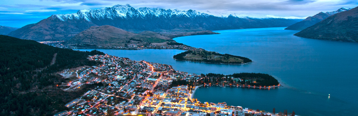
Photo: Queenstown from Bob's Peak by Lawrence Murray(CC BY 2.0)

Photo: Queenstown from Bob's Peak by Lawrence Murray(CC BY 2.0)
The 2019 New Zealand Geospatial Research Conference took place on 18 September, at the Queenstown Memorial Centre in Queenstown, Otago, in conjunction with the 15th International Conference on GeoComputation, GeoComputation 2019.
The 2022 NZGRC will take place in at Masset University in Wellington, 29-30 August. Find out more here.
The conference theme is Finding our way to a better future. Society is facing some significant global challenges: they are not necessarily new, but the awareness and urgency of these problems has escalated. The ability to effectively evaluate, understand and address these large-scale issues is vital if we are to make an impact on them. We are also on the cusp of a step-change in how we live and work in our work with disruptive technology and big data changing our futurescape. How we can harness these changes for the benefit of society is key.
Most of these challenges include a location component at a variety of scales. Geospatial information helps us to makes sense of the problems and gives us a better way of framing and addressing them. Knowing where people and things are, and their relationship to each other, is essential for evidence-informed decision-making. Not only is real-time information needed to prepare for, and respond to, things like natural disasters and political crises, but location-based services are helping governments to develop strategic priorities, make decisions, and measure and monitor outcomes.
NZGRC-2019 will bring the geospatial community together to explore how research in geospatial science and technology can help to address these challenges over the coming decades – both in terms of technological foundations and applied areas – and to consider how geospatial research can contribute to future societal wellbeing and just transitions.
Conference key thematic areas are:
Abstracts are available on this page – or click on a link in the programme table below.
8:15 | Registration |
|
9:00 | Opening welcome |
|
| Session 1: Keynote address |
|
9:05 | What progress have we made in the Spatial Sciences? | A. Prof. Peter Whigham (University of Otago) |
| Session 2: Opening plenaries |
|
9:40 | Keri Niven (Aurecon) |
|
10:10 | Creating Impact from Spatial Information | Nathan Quadros (Frontier SI) |
10:40 | Coffee |
|
| Session 3: Regular talks |
|
11:15 | Mapping NZ 2025 - integrating land and sea | Graeme Blick |
11:30 | Augmented GNSS - benefits to the NZ economy and its innovation opportunities | Matt Amos |
11:45 | Disaster risk reduction: frameworks and data | Robert Deakin, Kasey Oomen, Susan Shaw and Matthew Wilson |
12:00 | Jo Paterson and Ed Cook |
|
12:15 | Fine-grained automated data provenance for transparent environmental modelling | Alexander Herzig, Ben Jolly, Raphael Spiekermann, Tom Burleigh and David Medyckyj-Scott |
12:30 | Thomas Etherington |
|
12:45 | GeoAI: the future of feature extraction and classification | Sagar Soni |
13:00 | Lunch |
|
13:30 | Session 4: Posters |
|
| Danielle Barnhill, Laura Tilley, Thomas Wilson, Matthew Hughes and Sarah Beaven |
|
| Temporal drivers of Disaster Risk and Resilience in Rural New Zealand | Becca Fraser, Thomas Wilson, Sarah Beaven, Nicholas Cradock-Henry and Matthew Hughes |
| Laura Tilley |
|
| Development of a geospatial framework for analysis of water quality in Canterbury, New Zealand | Maria Vega-Corredor and Matthew Wilson |
| Session 5: Regular talks |
|
14:00 | One Billion Trees: A spatial analysis of reforestation scenarios for multiple benefits | Bradley Case |
14:15 | Audrey Lustig, Alex James and Michael Plank |
|
14:30 | Identifying high-risk agricultural activity in New Zealand hill country with remote sensing | Alexander Amies, Stella Bellis, Heather North, David Pairman, John Dymond, Jan Zoerner, James Shepherd and John Drewry |
14:45 | Usama Farooq, Wolfgang Rack and Adrian McDonald |
|
15:00 | What can a drone tell us about snow depth, and how can we decipher it? | Todd Redpath, Pascal Sirguey, Nicolas J. Cullen and Sean J. Fitzsimons |
15:15 | Ricardo Crespo and Claudio Alvarez |
|
15:30 | Matthew Hobbs, Alicia Wade, L Marek, M Tomintz, P Jones, K Sharma, J McCarthy, B Mattingley, M Campbell and S Kingham |
|
15:45 | Coffee |
|
| Session 6: Lightning talks |
|
16:15 | A new workflow for spatially enabling low-cost UAV Full Motion Video | Graham Hinchliffe |
16:25 | Digital Surface Model from aerial imagery for the Horizons Region | Andrew Steffert |
16:35 | A hi-fidelity approach for raster to vector conversions | Robbie Price |
16:45 | Melanie Tomintz, Maria Vega-Corredor, Simon Hoermann and Nawam Karki |
|
| Session 7: Closing Plenary |
|
16:55 | Lowering the Barriers to Scalable Geospatial Computation | Eric Shook, Coleman Shepard and Tyler Buresh (University of Minnesota) |
17:25 | Vote of thanks, Close |
|
18:00 | Ice Breaker, with GeoComputation |
|
20:00 | End |
Registration is now closed.
Tickets include morning and afternoon tea and coffee, lunch, and an networking icebreaker event in the evening. Purchased online only. Before the end of August there is a Standard entry fee of $150 and Student fee of $100 (exclusive of GST and booking fee). Late entry fees between the 1st and 16th September are $200 for standard and $150 for student entry fees.
We are offering discounted NZGRC-2019 ticket prices for GeoComputation attendees of $90 (Regular) or $40 (Student), to be paid on top of the GeoComputation registration fee. To take advantage of this, please head to the GeoComputation 2019 website to purchase your registration. If you are not attending GeoComputation, please purchase your registration for NZGRC-2019 here.
The conference is being organised by the Geospatial Research Institute Toi Hangarau in conjunction with the University of Canterbury, University of Otago, Victoria University of Wellington and Auckland University, in conjunction with GeoComputation 2019, running in Queenstown from 18-21 September.
Please contact us at:
Matthew Wilson,
Geospatial Research Institute,
Level 4, Julius von Haast Building,
University of Canterbury,
Private Bag 4800,
Christchurch, 8140,
New Zealand
Email: gri-enquiries@canterbury.ac.nz
You could also follow @GeospatialNZ on Twitter or connect with us on LinkedIn to be notified of conference related news.
Main organising team and programme comittee:
![]()