
GRI Members
Who we are
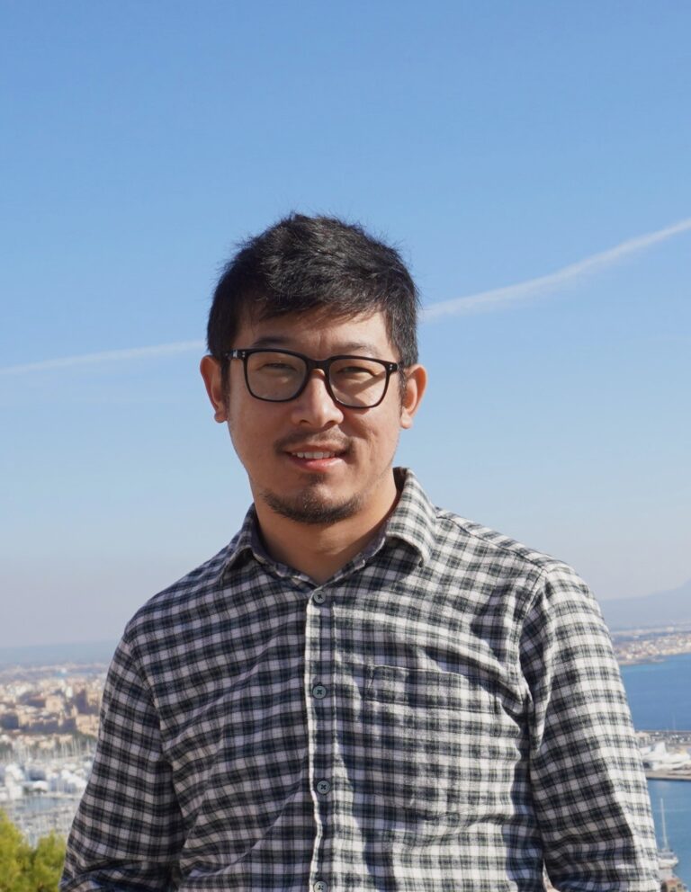
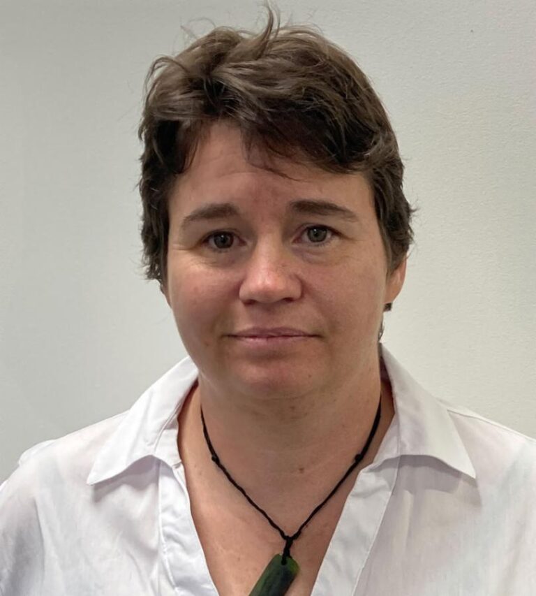
Dr Camila Cesar
Postdoctoral Fellow
Camila received her PhD in Physics from the University of Bern, Switzerland, in 2023. Her research focused on Martian polar processes, investigating seasonal CO₂ icy surface-atmosphere interactions using high-resolution multispectral satellite imagery and laboratory simulations. At the GRI, her current research explores methane emissions in Iwi agricultural systems, integrating satellite and ground-based data with modelling and machine learning workflows. She is particularly interested in data visualisation and science communication, aiming to support broader audiences in understanding current environmental challenges and to provide clear, evidence-based insights to policymakers.
Dr Phoebe Eggleton
Postdoctoral Fellow, GeoHealth Lab
Phoebe received her PhD in Health Sciences at the University of Canterbury in 2025. Phoebe is specifically interested in human geography, with her research focusing on population health. Her thesis examined the relationship between exposure to the Canterbury earthquake sequence (2010-11) and associated physical health outcomes. She enjoys using spatial methods in her projects to identify patterns and vulnerable populations. Click to see a video interview with Phoebe.
Dr Mike Kittridge
Postdoctoral Fellow
Mike is a hydrologic and atmospheric scientist that is a strong proponent of scientific work being reproducible, testable, open-source, and extendable. He also designs and builds systems for managing large amounts of data, develop the scientific processing and analysis tools that sit on top of these systems to do the data science magic, and create the reporting tools to present the results in the most valuable way for users. He’s had a varied career in the areas of clean(ish) freshwater science.
Dr Lukáš Marek
Postdoctoral Fellow, GeoHealth Lab
Lukáš received his PhD in 2015 from the Department of Geoinformatics at Palacky University in the Czech Republic. In his thesis, he conducted a research study on spatial and spatiotemporal analysis of Campylobac-teriosis in the Czech Republic. His main research interest is currently focused on geovisualisation and spatial analyses of health data using spatial and spatiotemporal modelling, and spatial statistics. Click to see a video interview with Lukáš.
Martin Nguyen
POSTDOCTORAL FELLOW
Martin’s research focuses on hydrology and machine learning applications. He is particularly interested in flood modelling uncertainty, sensitivity, and workflow design. He also enjoys applying machine learning approaches to advance such modelling challenges for computational efficiency. His work aims to improve accessibility of flood information, support decision making, and help communities through better flood understanding.

Darren Walton
POSTDOCTORAL FELLOW, GeoHealth Laboratory
Dr Darren Walton earned his PhD from the University of Canterbury. He has more than 20 years of research and industry experience, including work in transport, health promotion, and big data analytics that will contribute to the work of Te Taiwhenua o te Hauora | The GeoHealth Laboratory. Darren also has a programme of work examining harm to young people from online gaming. His core interest is promoting public health and wellbeing through his ongoing research projects.
Earlier in his career, he held multiple senior roles, including Director of Research and Evaluation at NZ Police and Director of Research at the Health Sponsorship Council. Dr Walton has led major data science initiatives across government, most recently working closely with the Ministry of Transport to support the Insights and Analytics team in developing emissions models.
Jesse Wiki
Postdoctoral Fellow, GeoHealth Laboratory
Jesse received her PhD in Geography from the University of Canterbury in 2019. She is interested in the intricate connections between geography, populations, and health. Her research focuses on the geographical nuances that influence everything from disease prevalence to healthcare accessibility by combining advanced statistical analyses with geographic information systems (GIS) to map out trends, identify disparities, and propose informed solutions. Click to see a video interview with Jesse.
Xander Cai
Geospatial Researcher
Xander Cai acquired a Master of Science degree in Data Science from the University of Canterbury and a Master of Engineering degree in Microelectronics and Solid-state Electronics from Huazhong University of Science and Technology. During years of service in the integrated circuit (IC) design and electronic design automation (EDA) fields in the research and development roles, he produced solid fundamentals and broad interests in state-of-the-art technology research, development, and application. His current research focuses on improving geospatial data processing and analysis based on deep learning, connecting communities with environmental change by leveraging visual reality technology.
Luke Parkinson
Senior Geospatial Software Developer
Luke is the GRI’s senior software developer, leading development for multiple projects. He has a strong interest in web and application development with a specialisation in geospatial technologies. Luke provides software development advice and support to researchers and leads teams to develop and deploy web applications and research data processing pipelines. He is leading development on the open-source digital twin framework being created at the GRI. Click to see a video interview with Luke.
Jamie Ruwhiu
Māori Engagement Specialist
Jamie is a recent addition to Te Whatu Ora, in the role of Public Health Emergency Manager – Te Waipounamu. He brings deep experience in emergency management, iwi engagement, and community resilience, having previously led the Whānau & Emergency Response Team at Te Rūnanga o Ngāi Tahu. Since joining his iwi after the March 2019 terror attacks, Jamie has supported responses to Cyclone Gabrielle, major floods, wildfires, and the COVID-19 pandemic. With a background spanning education, events, and hospitality, he takes a practical, whānau-focused approach to emergency management. Jamie is committed to culturally responsive, equitable outcomes for Māori in emergency and public health contexts.
Dr Rose Pearson
Postdoctoral Fellow, NIWA | Visiting researcher, GRI
Rose received her PhD in 2018 from the Department of Information engineering at Cambridge University in the United Kingdom. She is currently a postdoctoral fellow at NIWA and a visiting researcher at the Geospatial research institute. Her postdoctoral research focuses on combining geospatial data, primarily LiDAR point clouds, to produce hydrologically conditioned DEMs and roughness maps for use in river flood modelling. Her research interests centre on surface generation and attribute mapping from a wide array of spatial and geospatial datasets.
Clevon Ash
PhD Student
Clevon Ash who comes from the island of Trinidad & Tobago in the Caribbean, is a PhD candidate in the GRI and the Waterways Centre at the University of Canterbury. Having completed a Master of Disaster Management at The University of Auckland in 2021, he is now using his experience in Emergency Communications, Policy Development and Scientific Research towards improving the understanding and representation of uncertainty in flood risk management. His research is a part of the cross cutting theme of uncertainty in the MBIE Endeavour research programme, “Reducing flood inundation hazard and risk across Aotearoa/New Zealand”, also known as : “Mā te haumaru ō te wai” which means “By keeping the water safe”. Clevon is happy for the opportunity to work with different groups of stakeholders and researchers across New Zealand to improve the way that flood risks are managed. Click to see a video interview with Clevon.
Supervisors:
Prof Matthew Wilson
Prof Iain White (University of Waikato)
Dr Carolynne Hultquist
Katherine Booker
PhD Student
Katherine is a PhD candidate with the University of Waikato being hosted by the GRI. She has a professional background as an economist within government and commercial organisations and recently completed a Master’s degree in Applied Data Science at UC. Katherine’s PhD research draws on her professional experience and data science training to investigate how future urban growth projections can be generated by computational models. This research is part of the MBIE Endeavour research programme “Mā te haumaru ō nga puna wai ō Rākaihautū ka ora mo ake tonu: Increasing flood resilience across Aotearoa-New Zealand”. In addition to projections of location and severity of future flooding, including the implications of climate change, we also need to consider what future urban landscapes might look like. Where might people be living in 2050 or 2100? Katherine’s aim is to explore, test, and develop methods to generate a range of alternative long-term urban development scenarios for building into assessments of future flood risk. She is excited to be able to work with researchers and policy makers to support sustainable decision making in the face of a changing world. Click to see a video interview with Katherine.
Supervisors:
Prof Iain White (University of Waikato)
Prof Matthew Wilson
Dr. Xinyu Fu (University of Waikato)
Regina Chua
PhD Student
Regina is a Data Scientist and AI/ML Engineer dedicated to advancing environmental and health research. Supported by the UC Doctoral and GRI scholarships, she investigates the geographic patterns influencing the onset and progression of Parkinson’s Disease. Her dissertation draws on her professional and academic experiences in machine learning, network science, geospatial data science, and epigenetics, aiming to uncover critical insights that could improve patient outcomes.
Supervisors:
Dr Sinéad Moylett (University of Canterbury, School of Mathematics and Statistics)
Prof Malcolm Campbell (University of Canterbury, School of Earth and Environment)
Dr Lukáš Marek (University of Canterbury, GeoHealth Lab)
Dr Toni Pitcher (New Zealand Brain Research Institute)
Dr Daniel Myall (New Zealand Brain Research Institute)
Andrew Kindon
PhD Student, GeoHealth Laboratory
Andy is a practicing Clinical Vascular Physiologist, completing a HRC Clinical Research Training Fellowship with the Geo-Health lab. Andy has specialist clinical interest and expertise in the diagnosis and surveillance of Abdominal Aortic Aneurysms (AAAs). He is completing a PhD using geospatial techniques to improve our understanding of AAA epidemiology in New Zealand.
Supervisors:
Dr Matt Hobbs (University of Canterbury)
Professor Simon Kingham ( University of Canterbury)
Mr. Oliver Lyons (University of Otago)
Prof Justin Roake (University of Otago)
Andrea Pozo Estívariz
PhD Student
I am a civil engineer from Spain. Since my Master’s I have been working in the GeoOcean research group (University of Cantabria), having the opportunity to deep into different research topics such as the development and prediction models for tropical cyclone activity, wave modelling, rain fields parameterization or flood modelling and mapping. I have just started my PhD in the area of water resource management, focused on the development of advancing methods of rapid flood risk scenario assessment using hybrid approaches of hydraulic modelling and machine learning.
My PhD is supervised by Prof. Matt Wilson (UC), Dr. Emily Lane (NIWA) and Prof. Fernando Méndez (University of Cantabria, Spain) and it is part of the MBIE Endeavour research programme, “Reducing flood inundation hazard and risk across Aotearoa/New Zealand”. I am very motivated because this programme not only offers me the chance to work with cutting-edge techniques and learn more about such interesting topics for me like climate change; but also I feel I can contribute with my work to improve the quality of life of all the people who suffer from floods. Click to see a video interview with Andrea.
Supervisors:
Prof. Matt Wilson (UC)
Dr. Emily Lane (NIWA)
Prof. Fernando Méndez (University of Cantabria)
David Pedley
PhD Student
David has a professional background as an environmental lawyer and has recently completed a Master’s degree in landscape architecture at Lincoln University. Through this experience, David has established a strong interest in the potential of geospatial analysis to help develop effective solutions to complex environmental problems. David’s PhD is in urban forestry and will focus on the conflict between housing intensification and the loss of urban trees on private residential land in New Zealand cities. This research will incorporate deep learning techniques to detect changes in canopy cover over time and explore potential solutions to increase the retention of urban trees in the face of ongoing intensification pressure. David is very grateful for the opportunity to pursue this research through the Geospatial Research Institute Toi Hangarau PhD Scholarship, working alongside supervisors Dr Justin Morgenroth and Dr Grant Pearse. Click to see a video interview with David.
Supervisors:
Dr. Justin Morgenroth (UC)
Dr. Grant Pearse (Scion)
Sunil Tamang
PhD Student
Sunil comes from Langtang Valley, Nepal. He holds dual master’s degrees- one in Disaster Risk Management and another in Geospatial Technologies. Currently, he is pursuing his PhD research, focusing on the development of a machine learning framework to interpret earth observation data, with a specific emphasis on regional scale mapping of rock glaciers and other cryosphere landforms. Sunil is grateful and excited for the opportunity to pursue his doctoral studies, made possible through the Geospatial Research Institute Toi Hangarau PhD Scholarship, along with the University of Canterbury Doctoral scholarship. Click to see a video interview with Sunil.
Supervisors:
Dr. Shelley MacDonell (UC)
Dr. James Brasington (UC)
Dr. Benjamin Aubrey Robson (University of Bergen)
Dr Dean Walker
Adjunct Senior Fellow, GRI
Dean’s research interests include collaborations with Māori communities for the development of culturally-based frameworks and geospatial tools. His current research involves the development of map-based tools for community and Māori-led bicultural spatial planning, with iwi partners in Waimakariri and Rotorua. He has previously worked with iwi on projects in the Nelson region in the co-creation of tools for environmental monitoring.
Dr Ben Adams
Associate Professor, Dept. of Computer Science and Software Engineering, University of Canterbury
In my research I am exploring new ways of using computing technology to advance human understanding of our environment and world. I am interested in understanding, modelling, and improving how the people who want to learn about the world (e.g., scientists, students, and policy makers) interact with and make decisions based on geographic knowledge represented in a computer. The research I undertake is both explanatory and constructive. In the first case I work to develop theories that explain how the information that we produce and share in digital form reflects human conceptualizations of the world. In the second case I build software systems that help people use geographic information better to solve problems. My research methodology is informed by methods from data science, machine learning, spatial information science, interactive systems, and cognitive science.
Professor John Reid
Senior Research Fellow, University of Canterbury
John is a specialist in sustainability transitions. He is a Senior Research Fellow the Ngāi Tahu Centre, at the University of Canterbury. John works with iwi to plan sustainable development pathways in agriculture, forestry, and fishing. His current research focus is on nature-based solutions to climate change, declining biodiversity, and excess nutrient emissions. John is an Associate Editor of the Journal of the Royal Society of New Zealand and has several corporate and public governance roles.
Dr Matthew Hughes
Senior Lecturer Above The Bar | Pūkenga Matua, Nga Puanga Pūtaio Fellow
Department of Civil and Environmental Engineering | Pūhanga Metarahi me te Rawa Taiao
My research activities centre on the interplay between communities and natural and engineered systems. I conduct multidisciplinary and multi-agency research investigating how communities are impacted by and in turn influence the development of infrastructure, impacts of hazards on infrastructure and communities, and how long-term climate and landscape evolution processes will impact cultural heritage, settlements and infrastructure into the Anthropocene. I focus on integrating aspects of Te Ao Māori with earth science, and on infrastructure system development driven by iwi/hapū community aspirations, and impacts on these communities.
Dr Shelley MacDonell
Senior Lecturer in Hydrology Waterways Centre, University of Canterbury | Lincoln University
Shelley’s research focuses on cryosphere (snow and ice) science and cold regions hydrology. In particular she is interested in understanding the impact of climate change on catchment dynamics. She uses a combination of field, laboratory, and numerical methods to understand how snow and ice contribute to water supply, and how water is stored and transmitted through the landscape. She predominantly focuses on arid and semiarid environments, where an understanding of water availability is crucial for making decisions about use by people, or ecosystems, downstream. In these environments, glaciers and snow are often scarce but are the primary short- and long-term water sources, and so understanding their behaviour has implications for making decisions in the moment, as well as for long term policy perspectives. Her work is based in the Chilean Andes, Antarctica and Te Waipounamu.
Dr Marwan Katurji
Rutherford Discovery Fellow, Senior Lecturer in Atmospheric Dynamics, School of Earth and Environment, University of Canterbury
Dr Marwan Katurji specialises in surface-atmosphere interactions. His research interest is in modelling, simulating, measuring and analysing atmospheric phenomena, using advanced in-situ, aerial and remote sensing measurements and numerical modelling techniques. He is developing new approaches to tackle fundamental research questions in the field of atmospheric boundary-layer turbulence that leverages on a multidisciplinary approach of engineering and science. Marwan is particularly interested in coherent turbulent structures within the first 1km of our atmosphere above ground level (also called the atmospheric boundary-layer). These structures form the unique fabric of turbulence that controls the spatial variability of temperature and moisture across our landscape.
Dr Justin Morgenroth
Associate Professor, Postgraduate Director of Studies, School of Forestry | Kura Ngahere, University of Canterbury
I’m interested in understanding urban trees and the critical roles they play in cities around the world. The trees that comprise urban forests face considerable abiotic and biotic stress, but help to make cities liveable, providing residents with healthy, sustainable, and desirable places to live and work. To that end, I research the growth, function, management, and ecosystem services of trees in urban environments. To do so, I work extensively with remote sensing or earth observation techniques, including lidar, as well as aerial and satellite imagery.
Dr Matt Hobbs
Associate Professor and Transforming Lives Fellow in Spatial Data Science and Planetary Health (Sheffield Hallam University)
Matt is interested in how we can modify the food and physical activity environment to promote health. As an early career researcher, he recently completed his PhD for which he received a scholarship. His thesis explored the association between the physical food and physical activity environment and obesity. Most recently, he has been invited as part of the international advisory panel for Perspectives in Public Health a flagship journal of the Royal Society for Public Health (MRSPH). Matthew became a Fellow of the Higher Education Academy (FHEA & PGCHE), has studied and worked in Australia, at Loughborough University within the UK, and has also worked as a health, physical activity and obesity consultant.
Dr Sinéad Moylett
Data Science Project Coordinator, Lecturer School of Mathematics and Statistics | University of Canterbury
Dr Sinéad Moylett is a lecturer in data science with extensive expertise in biostatistics, epidemiology, and big healthcare data analytics. With experience spanning academia and private industry, she specialises in leveraging complex, high-dimensional datasets to generate actionable insights for informed decision-making.
Dr Simon Hoermann
Senior Lecturer, School of Product Design, University of Canterbury
User Experience researcher and academic in the School of Product Design, working in the area of human interface technology for health, training, and simulation applications.
Dr Tim Chambers
Associate Professor in the Ngāi Tahu Research Centre | University of Canterbury
Tim is a Fulbright Scholar (Harvard University) and Associate Professor in the Ngāi Tahu Research Centre. His research interests include environmental health and infectious diseases. Tim’s current research investigates the potential health burden of drinking water contamination, with a focus on nitrate contamination. Tim has also contributed to the Covid-19 response through his work on digital contact tracing for multiple Government agencies.
Dr Chambers uses spatial and quantitative research methods to understand the connections between place, space and health. Tim’s research also uses innovative technological solutions – such as wearable cameras, GPS devices and Bluetooth tracking devices to understand complex human behaviour. Tim’s research agenda also has a strong equity and policy focus.
Dr Chambers completed his PhD in public health at the University of Otago in 2018. Dr Chambers also has degrees in Physical Education and Classical Studies.
Dr Vanessa Bastos
Senior Lecturer School of Earth and Environment | University of Canterbury
Vanessa is a spatial data scientist whose research focuses on spatiotemporal modelling and big data analytics to understand human dynamics and environmental change. She holds a PhD in Geoinformatics from the University of St Andrews and is currently a Senior Lecturer at the School of Earth and Environment, University of Canterbury. She also holds an MSc in Remote Sensing and a BSc in Geography (majoring in GIS). Her work integrates diverse data sources, including GPS tracking, social media, transactional records, and location-based services, to explore patterns of individual and collective movement behaviour. Using data fusion techniques, she investigates population-level mobility-related processes, particularly in urban environments. Originally from Brazil, Vanessa brings a global, interdisciplinary perspective and is committed to using spatial data science for sustainable development, inclusive planning, and geospatial equity.
Dr Rodrigo Gomez-Fell
remote sensing scientist | University of Canterbury
Dr Rodrigo Gomez Fell is a remote sensing scientist specialising in synthetic aperture radar (SAR) and LiDAR to investigate how surface processes contribute to observable environmental change. His research spans glaciology, fluvial geomorphology, and oceanography, with applications in Antarctica, Patagonia, and New Zealand. He has worked extensively on ice-ocean interactions, glacier velocity dynamics, fjords and river systems, integrating SAR, optical, and LiDAR datasets to analyse surface evolution. He has also worked with airborne LiDAR and satellite-based remote sensing to study braided river geomorphology and glacier dynamics in New Zealand. Currently, his focus is on the cryosphere and the ice-ocean boundary, as well as the backscatter mechanisms of SAR over glacier snowpack and firn. His work also explores the fusion of high-resolution SAR data with optical satellite imagery and machine learning to quantify long-term environmental change. Beyond research, Dr Gomez Fell is actively involved in the IEEE GRSS, in science communication and mentoring, contributing to university teaching and international collaborations in Earth observation and environmental monitoring.
Dr Sidney Wong
Researcher and Community Advocate | Centre for Sustainability Research at the University of Otago
Dr Sidney Wong is a researcher and community advocate based within the Centre for Sustainability Research at the University of Otago. He currently works as a postdoctoral fellow in the Modelling for Impact Hub at Te Pūnaha Matatini, the Centre of Research Excellence for Complex Systems. His research focuses on enabling digital inclusion and social resilience through data and modelling.
Sidney completed his PhD in Linguistics at the University of Canterbury, supported by a Geospatial Research Institute PhD Scholarship. His thesis examined geographic dialect alignment in New Zealand-related Reddit communities by combining qualitative user insights with computational language modelling. Through the analysis of a 4.26-billion-word corpus, his research demonstrated how place-based digital communities reflect identity and linguistic change within New Zealand English.
A recipient of a Fulbright Science and Innovation graduate award, Sidney applied the insights of his doctoral research to explore automatic hate speech detection at the University of Illinois Urbana-Champaign. Through this work, he advocated for AI-driven detection systems to account for socio-cultural factors and the specific impacts these systems have on communities. He previously held the role as a Senior Design Analyst (Te Ara Takatū) at Stats NZ where he worked with iwi- and hapū-led organisations to support their data needs.
Dr Emily Lane
Hydrodynamics Scientist, NIWA
Dr Delwyn Moller
Adjunct Professor, Department of Electrical, Computer and Software Engineering, University of Auckland
Prof. Elena Motchanova
Head of the Statistics Consulting Unit, School of Mathematics and Statistics, University of Canterbury
Greg Preston
Manager – Industry Development, Buiding Innovation Partnership; Research Manager, Quake Centre, University of Canterbury
Professor Matthew Wilson
Kaihautū | Director, Geospatial Research Institute Toi Hangarau
Ahorangi | Professor, School of Earth and Environment – Te Kura Aronukurangi
Addressing key research questions around Spatial Data Infrastructures (SDI), as well as associated management and governance topics related to spatial data management, spatial data integration and sharing, interoperability and standards, data models, governance, and legal issues associated with open data and data privacy.
Professor Jennifer Brown
Deputy Director, Geospatial Research Institute
Head of School for School of Mathematics and Statistics at the University of Canterbury, Christchurch, New Zealand, Jennifer is an Associate Director of the Biomathematics Research Centre and researcher in the NZ Health Ageing Research Group. She has an undergraduate degree in Forestry from Canterbury University.
Professor Simon Kingham
Deputy Director, Geospatial Research Institute
Chief Science Adviser for Ministry of Transport
Research interests include three areas, broadly linked by relationships between transport and health. These are:
1. Air pollution exposure – This addresses the question of how we quantify the amount of pollution humans actually breathe in. This is important to know if we want to relate pollution to human health.
2. Transport – This research area is interested in how we can make transport more sustainable and looks at people’s perceptions and attitudes to transport, focusing specifically on school and work travel.
3. Health geography – This focuses on links between spatial patterns of illness and air pollution.
Maria Cecilia Vega-Corredor
Menetia | Manager, Geospatial Research Institute Toi Hangarau
Maria is a Doctor of Veterinary Medicine with an MSc in Tropical Ecology. Over the last several years, she has been working in research in the spatial epidemiology of zoonotic diseases, with a particular focus on their geographical variations and associated risk factors including ecological, environmental and climatic.
Professor Malcolm Campbell
Director of the GeoHealth Laboratory
Professor, School of Earth and Environment, University of Canterbury
Professor Campbell is a Quantitative Human Geography with expertise in Health and Medical Geography as well as Urban and Regional Analytics. He is the current Director of the GeoHealth Laboratory at UC and the founder of the Regional Analytics Lab. Dr. Campbell has primary research themes in mGeoHealth and Health Geography. He also has research themes in regional studies and science with a focus on regional analytics. Malcolm is working on a series of projects that examine and attempt to understand social and spatial inequalities for different populations, processes and places.
Hannah Walker
Marketing Administrator, Geospatial Research Institute
Hannah has a Master of Fine Arts in Natural History Filmmaking and Communication from Montana State University and a Dual BA/BS from the Evergreen State College. She specialises in science communication and marketing.
Jan Pierce (Chairperson)
Kaihautū Deputy Secretary Customer Delivery at Toitū Te Whenua Land Information New Zealand
Lucy Johnston
Deputy Vice-Chancellor Research and Innovation, University of Canterbury
Dr Kat Salm
Consultant, UrbanKind
Peter Shaw
Engineering Director, Cloud (Geospatial), Trimble
Mike Taitoko
CEO Takiwa, co-founder of Toha and Calm The Farm
Jennifer’s primary research interests are in environmental statistics and she has expertise in survey design and environmental monitoring. Her research areas are broad and she works in other application areas, most recently, human health and wellbeing.
Professor Malcolm Campbell
Director of the GeoHealth Laboratory
Professor, School of Earth and Environment, University of Canterbury
Professor Campbell is a Quantitative Human Geography with expertise in Health and Medical Geography as well as Urban and Regional Analytics. He is the current Director of the GeoHealth Laboratory at UC and the founder of the Regional Analytics Lab. Dr. Campbell has primary research themes in mGeoHealth and Health Geography. He also has research themes in regional studies and science with a focus on regional analytics. Malcolm is working on a series of projects that examine and attempt to understand social and spatial inequalities for different populations, processes and places.
Professor Richard Green
Sourcing and Delivery Theme Leader at the Department of Computer Science and Software Engineering
Theme Leader of Geospatial Research Institute
Incorporating a range of topics related to spatial data sourcing and delivery, including research work in UAVs, sensors, WiFi networks, environmental telemetry, positioning, mobile technology, communications, crowdsourcing, and representation of indigenous knowledge.

Professor Rob Lindeman
Director, HIT Lab NZ
Incorporating big spatial data analytics and rapid spatial data analytics, complex system modelling, geo-visualisation and interpretation, and GIS interfaces with other systems such as BIM. It also includes human aspects of data representation.
Professor John Reid
Ngāi Tahu Research Centre
John is a specialist in indigenous economic development with a particular focus on land, freshwater, ocean, and housing sustainability. He has spent years as both a consultant and researcher developing hapū and iwi scale businesses and economies. He also has a strong interest in indigenous identities and relationships to place that underpin novel approaches to social and economic development.
Dr Graeme Woodward
Wireless Research Centre
The applied use of geospatial for smart cities and infrastructure development and management, including smart cities, intelligent transport systems, business intelligence, situational awareness, built environment planning, monitoring and management, emergency services, post-quake city geoscience, and smarter as-set/utilities/infrastructure management.