
Te Kete Kōrero o Ōhinemutu; Geospatial tool for community & Māori-led planning
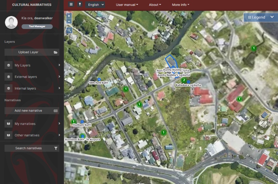
Te Kete Kōrero o Ōhinemutu is a Mātauranga Māori map-based tool co-created by the community of Ōhinemutu and the Geospatial Research Institute Toi Hangarau. Ōhinemutu is a village with deep connection to Ngāti Whakaue. Built on the shores of Lake Rotorua, it is famed for its geothermal features and Te Papa-i-Ouru marae. Te Kete Kōrero o Ōhinemutu has been built to hold and share historical narratives of Ōhinemutu as well as current community initiatives. The range of narratives includes traditional, historic, scientific and lived experiences.
ESP features on Architecture Now website
Designed to disrupt: A digital tool for urban regeneration The National Science Challenges are government funded initiatives that are designed to set strategic goals for creating a better Aotearoa. The 11 challenges cover topics ranging from childhood education to ageing and nutrition to ecology. Researchers in the architecture, urbanism and design fields from universities around […]
Map-based tools for community and rūnanga-led sustainable town planning
University of Canterbury Science and Engineering researchers have gained $10.7 million in funding for five Smart Ideas proposals and two Research Programmes in the Ministry of Business, Innovation and Employment’s 2017 Endeavour Round. UC researcher, Dr Rita Dionisio, is leading a new Research Programme creating map-based tools for community and rūnanga-led, sustainable town planning in […]