PhD student:
Andrea Pozo Estivariz (PhD student, UoC)
Supervisors:
Matthew Wilson (UoC)
Emily Lane (Earth Sciences NZ)
Marwan Katurji (UoC)
Fernando Méndez (Universidad de Cantabria)
Cyprien Bosserelle (Earth Sciences NZ)
Funding:
MBIE Endeavour Research Programme – Increasing flood resilience across Aotearoa, New Zealand.
Duration:
2021 – 2025
Summary:
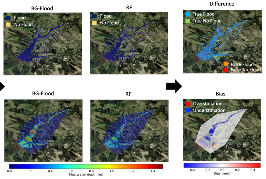
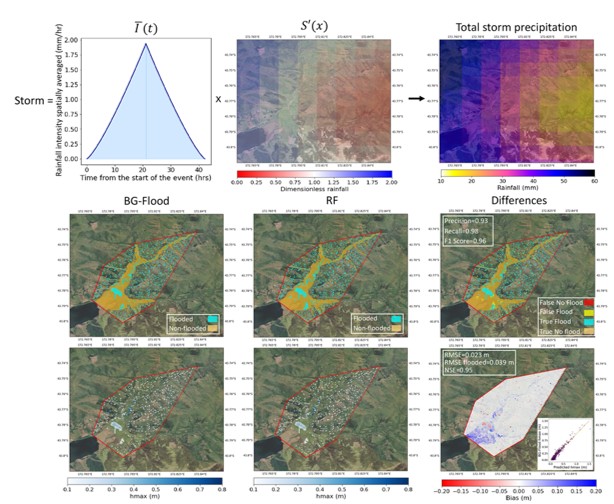
Flooding is among the most devastating natural hazards affecting communities, infrastructure, economies and ecosystems. As climate change impacts become realised, flood patterns are expected to change, leading to more extreme events. This context poses critical challenges to current flood risk assessment strategies. Therefore, it is increasingly crucial to develop robust tools that support practical flood risk assessment. This thesis focuses on a key part of flood risk assessment: pluvial flooding drivers and inundation. This research develops reliable, computationally efficient and flexible climate-informed tools that can be used to assess pluvial flood likelihood and inundation hazard and impact. These tools enhance the understanding of the main inundation driver (heavy rainfall) and enable climate-informed rapid flood inundation scenario assessment, large ensemble flood inundation scenario analyses, and long-term flood risk assessment. These tools are developed using a combination of statistical, machine learning, and two-dimensional hydrodynamic modelling techniques. A method to statistically characterise local flood-inducing heavy rainfall using synoptic climatology and large-scale climatic patterns was first developed. Useful relationships were found between the synoptic and large-scale climatic patterns and heavy rainfall and flooding. This analysis provided both qualitative and quantitative value, displaying the range of weather and climatic configurations that lead to different types of storms and flooding, and helping in their identification and understanding. Drawing on the knowledge acquired in this study, two climate-informed hybrid hydrodynamic-machine models for rapid pluvial flood inundation hazard assessment were developed: a hybrid model for flood/non-flood prediction and a hybrid model for predicting maximum inundation depth. These hybrid models can be used for rapid and accurate assessment of flood inundation scenarios, enabling ensemble scenario analyses. Lastly, to progress beyond more event-targeted models and enable long-term probabilistic flood risk assessment, too, a framework for pluvial flood risk inundation assessment based on a climate based emulator of storms was developed. The developed approach provides a comprehensive, reliable, and flexible framework for evaluating pluvial flood likelihood and inundation hazard impact. The proposed approaches are implemented and validated in a study site (Aotearoa New Zealand – the Wairewa rural catchment). However, they are conceived to be transferable and generalisable to other locations due to their flexible structure. Their adaptability also allows for the integration of climate change considerations. The developed methods are also designed to be interpretable and practically accessible, to be eventually integrated into a flood risk assessment operational framework.
Outputs:
Pozo, A., Wilson, M., Lane, E., Méndez, F. and Katurji, M. (2023). Towards a method of rapid flood scenario mapping using hybrid approaches of hydraulic modelling and machine learning, EGU General Assembly 2023, Vienna, Austria, 24–28 Apr 2023, EGU23-2462, https://doi.org/10.5194/egusphere-egu23-2462.
Pozo, Andrea. Cross validation of characterisation of rainfall extreme events between rain gauge data and WRF model in North Canterbury. Waterways Postgraduate Students Conference, Christchurch, 8 November 2022.
Pozo, A., Wilson, M., Katurji, M., Méndez, F. and Lane, E. Analysis of New Zealand Daily Weather Patterns (DWTS) and Large-Scale Climatic Patterns as Extreme Rainfall and Flooding Drivers. The Fourth Spatial Data Science Symposium. UoC, Christchurch, September 5, 2023. Poster.
Pozo, A. Analysis of New Zealand daily weather patterns (DWTs) and large scale climatic patterns as heavy rainfall and flooding drivers. Australasian Groundwater & New Zealand Hydrological Society Joint Conference. Auckland, December 2023.
Pozo, A., Wilson, M., Katurji, M., Cagigal, L., Méndez, F.J. and Lane, E. (2025). Characterising Local Flood-Inducing Heavy Rainfall Through Daily Weather Types and Large-Scale Climatic Patterns: Aotearoa New Zealand Study Case. Int J Climatol, 45: e8762. https://doi.org/10.1002/joc.8762