
Geospatial Research Seminar Series (GRISS) – 26 November 2021

Speaker: Dr. Philipp Sueltrop, CTO Kea Aerospace
The Geospatial Research Institute is pleased to host Dr. Philipp Sueltrop.
Philipp is the Chief Technology Officer of the Christchurch-based company Kea Aerospace. Besides leading the technical development team of the unmanned solar-powered aircraft Kea Atmos, he considers himself as a technology explorer combining his passion for aerospace engineering that can provide the means for advantageous scientific, civil and commercial contributions.
New PhD student Andrea Pozo Estívariz joins the GRI
We are pleased to welcome Andrea Pozo Estívariz as a PhD student within the Geospatial Research Institute. Andrea summarises her PhD below: “I am a civil engineer from Spain. Since my Master’s I have been working in the GeoOcean research group (University of Cantabria), having the opportunity to deep into different research topics such […]
Geospatial Research Seminar Series (GRISS) – 29 October 2021 – Recorded
Since 2004 Professor Richard Green has been lecturing in computer science at the University of Canterbury after running his own successful 50 staff software company in Sydney (sold to a multinational). With over 200 refereed publications, Richard heads the Computer Vision Research Lab with an emphasis on autonomous robot vision/deep learning (robots/drones/underwater robots) and analysing human movement.
New PhD student Sidney Wong joins the GRI

We are pleased to welcome Sidney Wong as a PhD student within the Geospatial Research Institute. Sidney is excited to be offered the opportunity through the Geospatial Research Institute Toi Hangarau PhD Scholarship to model the social and linguistic characteristics of local populations using geo-referenced language data. He was attracted by the transdisciplinary nature of […]
Geospatial Research Seminar Series (GRISS) – 24 September 2021 – Recorded

Keri is a passionate Digital Technologist, with a strong background in Geospatial technologies, and over 20 years of international experience in designing enterprise collaboration platforms. Keri is the New Zealand Digital Practice Leader and is focused on identifying digital possibilities and creating opportunities to embed new technologies into our organisational way of working. Keri represents Aurecon on the ANZ Smart Cities Council and on the ANZ Digital Twin Taskforce.
Geospatial Research Seminar Series (GRISS) – 30 July 2021
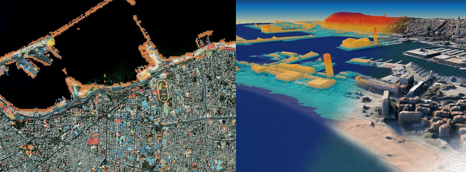
In this time of rapid global change, we need new ways to identify, monitor and understand the impact of change on environments and human dynamics such as economy, health and sociopolitical stability. Maxar Earth Intelligence capabilities help customers map, detect, address and predict change at unprecedented speed and scale. Fueled largely by Maxar’s own constellation of high-resolution imaging satellites and combining multi-source data and applied artificial intelligence, machine learning and rich domain knowledge is able to deliver insight as a service.
Geospatial Research Seminar Series (GRISS) – 25 June 2021
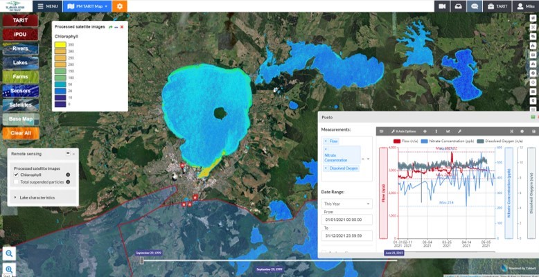
Takiwā is an award winning data management and analytics platform that allows end-users to upload, analyse and present multiple types of data and information within a spatial context in order to solve complex problems. A critical design feature of Takiwā has been the ability to draw together cultural and maatauranga Māori data and information alongside Western scientific data while managing cultural and commercial sensitivities of any datasets. Takiwā CEO Mike Taitoko will introduce the Takiwā platform and illustrate how it can help to empower…
Geospatial Research Seminar Series (GRISS) – 28 May 2021

NZ now has a tool that has been developed to identify high risk locations for safety interventions in order to reduce the horrific financial and emotional cost of road fatalities. The Safer Journeys Risk Assessment Tool or more commonly, ‘MegaMaps’, and has been produced by Waka Kotahi NZ Transport Agency with the assistance of Abley, a national professional services firm. The tool is a significant asset for New Zealand. This presentation will explain the tool, how it came to exist and why it is unique nationally and globally.
UC team scoops third place in the TakiWaehere Geospatial hackathon!
The hackathon, which took place over the weekend of 17-18 April was a great success, with 40 submissions received. Key judging criteria included creativity, the problem/ opportunity addressed, the novelty of the solution, and the potential competitive advantage of the solution. During the award ceremony on 23 April, Joe McKay (MBIE) mentioned that this was […]
Geospatial Research Seminar Series (GRISS) – 30 April 2021
Much has been written about the need to unlock the power of data and digital methods to improve the performance of infrastructure and productivity of the building industry. Recognising the potential benefits of these methods, the New Zealand Government and building industry are co-investing in an eight-year (2018-2026) research programme, under the banner of the Building Innovation Partnership (BIP), to accelerate digitalisation of the infrastructure sector. This industry-led programme has to date focused on two applications of data and digital methods.