
Sunil Tamang, a GRI scholarship recipient/PhD candidate is currently participating in the Himalaya Climate Data Field Lab 2024
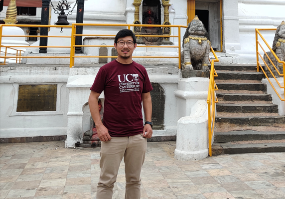
The Himalaya Climate Data Field Lab 2024 is an innovative workshop where over 100 researchers, artists, and activists come together in an unconventional setting to collaborate and shape the program as it progresses over the course of a month and beyond. His participation in the workshop is for three weeks. Sunil is specifically involved in […]
GRI PhD Candidate, David Pedley invited to present at upcoming ForestSAT conference
David Pedley will be presenting “Detecting and measuring urban tree canopy loss at the property scale with remote sensing data” at upcoming ForestSAT conference in Rotorua Sept 2024. For more details, visit: https://www.forestsat.com/
Virtual reality brings flood risk to life
The GRI Director, Professor Matthew Wilson, has been awarded funding from an EQC Biennial grant. The project called “virtually flooded” has been developed in partnership with leaders from Te Rūnanga o Ngāi Tahu (TRoNT) and has been featured in a recent TechWeek EQC article entitled, “Tech-savvy scientists are helping New Zealanders prepare for natural hazards.” This […]
Visiting PhD Student, Joe Lillis
GRI has a visiting PhD student from Exeter University in the UK. Joe Lillis has been working on a thesis that aims to map how greenspace, air pollution, and traffic noise impacts mental health in the UK. While at UC, Joe has helped the GeoHealth Lab create a greenspace national composite for New Zealand based […]
MIGARS 2024
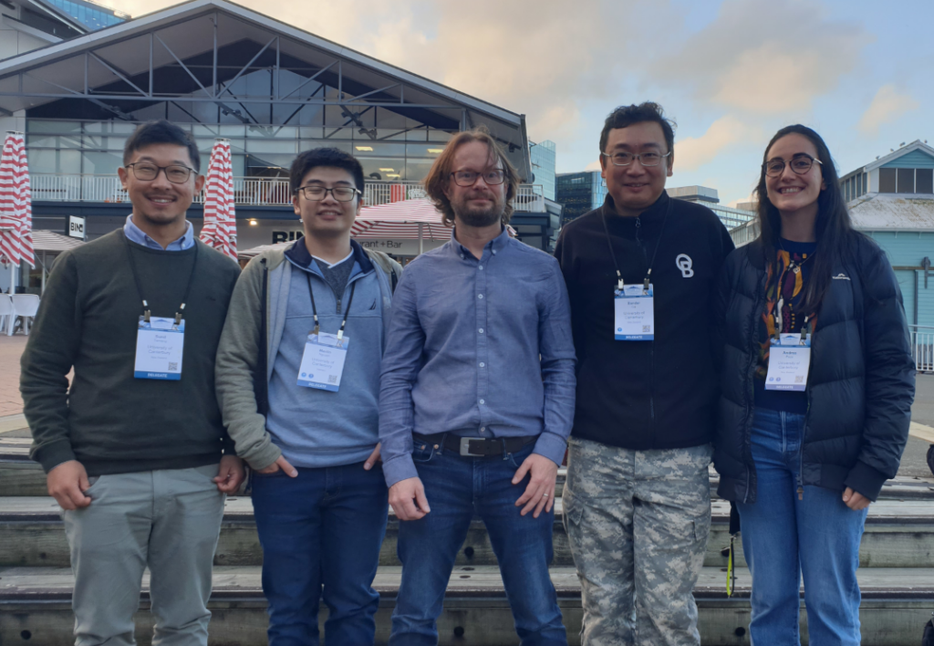
The GRI was well represented at the MIGARS conference (International Conference on Machine Intelligence for Geoanalytics and Remote Sensing ) in Wellington this week. Congrats on all the posters and talks.
Six papers on machine learning from GRI to be presented at MIGARS 2024
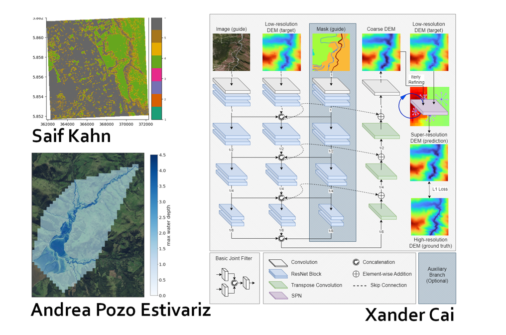
Thrilling work in machine learning developed in the GRI is going to be presented in the forthcoming 2024 MIGARs International Conference on Machine Intelligence for Geoanalytics and Remote Sensing. The papers are: Detecting Vegetated Wetlands of New Zealand through Satellite Imagery and Machine Learning- Saif Khan Learning with Image Guidance for Digital Elevation Model Super-Resolution […]
Dr Matthew Hobbs is lead author on a new research paper

A recent international study led by Dr Matthew Hobbs, Senior Lecturer and Co-Director of the GeoHealth Laboratory in the Geospatial Research Institute at Te Whare Wānanga o Waitaha | University of Canterbury (UC), sought to throw some light on these underlying factors. Joining him in the endeavour were UK researchers from the University of Essex, […]
How much habitat is enough?
In this seminar, Dr Cristina Banks-Leite will talk about ecological thresholds as a was to estimate the minimum amount of habitat required to preserve biodiversity, and how the position of thresholds changes across biomes world-wide.
The GRI Director, Prof Matthew Wilson awarded with one of four IIT-Delhi Fellowships
Te Whare Wānanga of Waitaha | University of Canterbury (UC) academics have been awarded two of four inaugural IIT-Delhi India-New Zealand Centre Fellowships. For more information go to: https://www.canterbury.ac.nz/news-and-events/news/2024/iit-delhi-fellowships-awarded-to-university-of-canterbury-resear Congratulations Matt!
Radio localisation: Understanding insect behaviour, busting sport cheats and studying climate change.
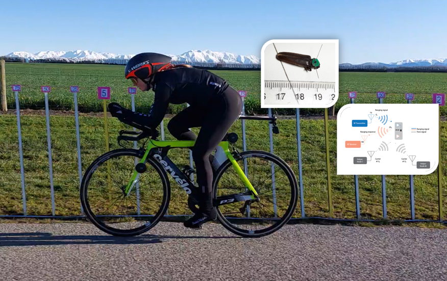
In this seminar, Dr Graeme Woodward will be introducing some of the work at UC’s Wireless Research Centre.