The hackathon, which took place over the weekend of 17-18 April was a great success, with 40 submissions received. Key judging criteria included creativity, the problem/ opportunity addressed, the novelty of the solution, and the potential competitive advantage of the solution.
During the award ceremony on 23 April, Joe McKay (MBIE) mentioned that this was the first joint initiative between MBIE and Maxar, and that we can expect many more to come. Kumar Navulur (Maxar) observed how much talent there was on display in the submissions, with demonstrated expertise in programming, remote sensing, artificial intelligence and machine learning, with several submissions using innovative techniques based on computer vision. Teams also did some good research to scope why their chosen challenge is important to New Zealand, with several also presenting the economic aspects of the implications of the challenge. Navulur said that the team spirit in the competition was clear, especially in the videos submitted to illustrate the teams’ solutions, where it looked like everyone had a lot of fun.
The third place winner was the team South Island Students (aka Team SeeReef) of the University of Canterbury for their application “SeeReef”. The third place prize consists of $5000 NZ cash to the winning team, 1 month SecureWatch data access from Maxar (25 Gb limit, 10 users), and a “space selfie” of the winning University. Team SeeReef completed their challenge under the theme of planning for a changing coast. Navulur commented that the team presented their app with excellent packaging, approached from a computer vision stand point but using geography and GIS as critical inputs to the solution.
The Team SeeReef members are: Henry Seaton, Georgia Reynolds, Fletcher Walmsley, Sam Hogan, Hank Wu and Zach Preston. All team members are 4th year mechatronics students from the College of Engineering, and were mentored by Prof. Richard Green with additional advice from several others. The team assigned roles for the hackathon across computer vision processing, backend development, frontend development, writing and design. The developed app is available at http://seereef.ddns.net/ (see below), and a video which introduces it is on YouTube here: https://youtu.be/5eoTIVopWiQ. The team says that:
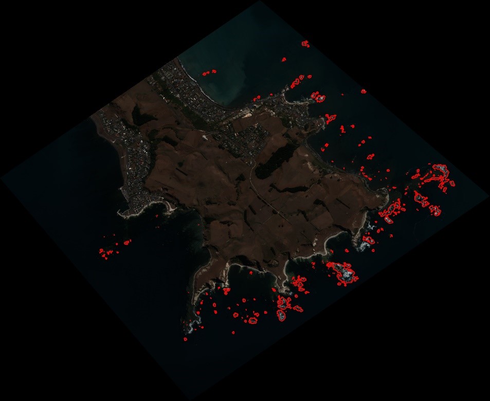
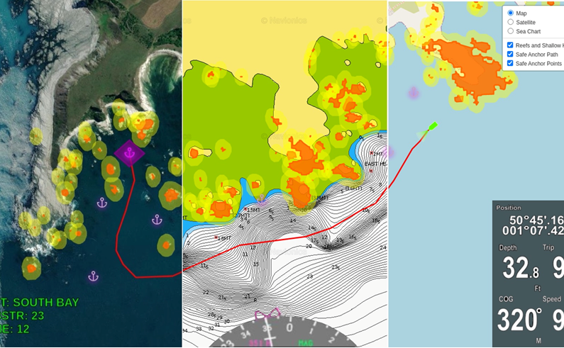
“SeeReef is a maritime navigational tool that identifies hazardous features in shallow waters. As existing seacharts do not have the resolution or update-rate to track small, shallow water features, navigating through our changing coastal waterways is challenging even for experienced mariners. SeeReef overcomes this by providing near real time detection of mobile coral bommies, submerged rocks and sandbars.
“With underwater collisions being a leading cause of ecosystem damage, and maritime cost, our ambition is to provide mariners with the information they need to ensure safe passage and anchorage in shallow waters. The SeeReef overlay illustrates hazards identified from our OpenCV computer vision pipeline. With integrations to existing chart-plotting software, SeeReef may autonomously map safe passages and determine safe anchorage locations that free of rocks or coral bommies.”
During the ceremony, the award was received by Henry and Georgia, who said that they are excited to have won and thanked everyone for all the support received, particularly from mentors and the judges. Asked about what was the best aspect of the hackathon, Henry said that it was fun to sit down under time pressure for a focussed 24 hours and really get things done on the project.
The second place prize ($5000 NZ cash, 3 months SecureWatch data access, 50 Gb limit + a “space selfie”) went to the Interpolators, a joint team from AUT and University of Auckland. Their app provides an automated assessment of local water ways health, using a novel river health index created from the multispectral bands of the Maxar imagery. Navulur stated that there is lots of potential for development of real-world applications and that it was a close second. In receiving the award, Morgan Dolfing from the team said that the specialist knowledge of an environmental scientist on the team was crucial, alongside other team members who are computer scientists.
The first place prize ($5000 NZ cash, new imagery tasking, 3 months SecureWatch data access, 50 Gb limit + a “space selfie”) went to the Auckland University Neuro Transmitting Students (AUNTS) team, from the University of Auckland, for their app Detection and Monitoring of Floods (DeMoF). Navulur stated that this was a well-rounded project that identifies and solves a real world challenge through the use of a GIS interface, and made good use of the spectral signatures to provide rapid flood impact assessment. In receiving the award, Olly and Amelia said that the team of 4 had a wide range backgrounds and it was this that made the team strong.
MBIE will showcase the winning teams solutions during TechWeek 2021 (22-30 May), enabling the teams to present their solutions to the industry.
The Geospatial Research Institute will organise an internal UC event to come together and celebrate all teams’ efforts, and arrange for the “space selfie” to be captured; it will also follow up with additional support to further develop apps.
Congratulations all winners and participants!