We invite the Geospatial community to attend or present geospatial work at the upcoming Sixth Spatial Data Science Symposium.
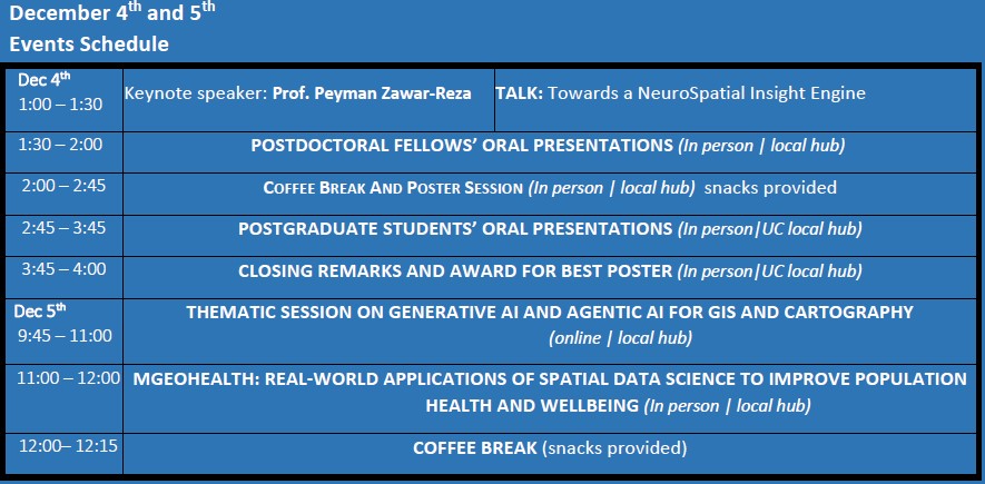
SDSS2025 is a distributed/online symposium. Participants are welcome to join one of the symposium hubs distributed around the world. Groups of participants will meet at these hubs to present and discuss with other participants both in person and online. The UC local hub will convey at the University of Canterbury in the Ernest Rutherford building, room 263 from 1pm-4pm on Thursday 4th of December and on Friday December 5th from 9:45am to 12:15pm. Please see activities listed under the Events Schedule below.
Register for free at: HUMANITIX https://events.humanitix.com/sdss2025uchub to attend in person at the UC local hub.
CALL FOR POSTERS AND ORAL PRESENTATIONS:
We invite undergraduate and postgraduate students to submit their own geospatial research projects in the form of posters. The best presented and creative poster will receive a voucher of $100 sponsored by the Geospatial Research Institute Toi Hangarau.
We also invite postgraduate students and postdoctoral students to submit their own geospatial research projects in the form of 5-minute oral presentations.
Topics of interest for submissions include, but are not limited to:
Mapping, Spatial analysis and modelling, Geospatial data management and integration, Geovisualization and cartography, Spatial databases and data mining, Remote sensing and satellite imagery analysis, Web-based GIS and geospatial services, Mobile GIS and location-based services, Geospatial technology applications in various domains, geospatial data ethics and privacy, indigenous GIS, open-source geospatial tools and software.
SUBMISSION GUIDELINES:
Contributions must be submitted via email to gri-enquiries@canterbury.ac.nz by Nov 14th. Submissions should include a title and an abstract (maximum 200 words).
POSTER PREPARATION TIPS
Place the title of your paper clearly at the top of the poster to allow viewers to easily identify your paper. Indicate the authors’ names and address information in order to allow interested viewers to contact you for more information.
Prepare all diagrams or charts neatly and legibly beforehand, in a size sufficient to be read at a distance of 1.5–2.0 m. The type is recommended to be 2.5 cm high. Use different colours or line-types for each line or bars contained in your graph or chart.
Organize the poster in a way that it is clear, orderly, and self-explanatory. The poster must cover the same content as the abstract. Label different elements as 1, 2, 3, or A, B, C. This will make it easier for a viewer to follow your display.
Include the background of your research followed by results and conclusions. The success of a poster presentation is contingent on how well you convey the information to an interested audience.
Please ensure that the paper you print your poster on does not shine through.
ABOUT THE SIXTH SPATIAL DATA SCIENCE SYMPOSIUM | DECEMBER 4 & 5, 2025 | DISTRIBUTED & ONLINE
Spatial and temporal thinking is important not just because everything happens at some places and at some time, but because knowing where and when things are happening is key to understanding how and why they happened or will happen. Spatial data science is concerned with the representation, modelling, and simulation of spatial processes, as well as with the publication, retrieval, reuse, integration, and analysis of such space- and place-centric data. It generalizes and unifies research from fields such as geographic information science/geoinformatics, geo/spatial statistics, remote sensing, environmental studies, and transportation studies, and fosters applications of methods developed in these fields in other disciplines ranging from social to biological and physical sciences. To keep this discussion alive and help the community to exchange ideas and lessons learned about spatial and temporal aspects of data science, we are hosting the 6th Spatial Data Science Symposium (SDSS 2025) as a distributed virtual meeting. For more details on SDSS 2025 check http://sdss2025.spatial-data-science.net/