Date
September 5-6, 2023
Submitted to
The Fourth Spatial Data Science Symposium
Authors
M. Nguyen, M. D. Wilson, E. M. Lane, J. Brasington, R. Pearson
Introduction
River bathymetry plays a crucial role in flood modelling in the form of Digital Elevation Model (DEM). It increases the reliability, accuracy and continuity of the DEM. However, river bathymetry is not always available in data-scarce areas because of the time-intensive and expensive data collection process. This leads to the development of numerous conceptual models and interpolation algorithms for approximating river bathymetry (Neal et al., 2021). However, due to limitations in acquiring real-world data and in algorithms, these estimations can introduce implicit uncertainties which can propagate to the model results. These uncertainties will have a direct impact on the amount of flow discharge along the river, which in turn will impact the level of flood depths in the floodplain.
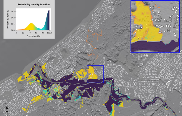
This research investigated the variation in the outputs of a flood model, where multiple DEMs were generated from topographic LiDAR and bathymetric data estimated by formula of Rupp and Smart (2007), and each was used to predict flood inundation. In that, the values of the flow discharge, the channel width, and the channel slope used to estimate the bathymetric data for Waikanae River area, New Zealand were adjusted to produce multiple DEMs. These DEMs containing different riverbed (bed) elevation information were then used in the hydraulic model LISFLOOD-FP to generate the flood maps. The variability in the results was then analysed statistically, allowing the sensitivity of model predictions to be assessed.
Click to view or download the PDF of the poster.


