
Researchers: Rita Dionisio (Principal investigator, GRI and SEE-TKA)
Dean Walker (Post-doctoral fellow GRI)
Ines Falco (Software developer GRI)
Sharmila Savarimuthu (Software developer GRI)
Luke Parkinson (Software developer GRI)
Professor Hirini Matunga (key researcher, Lincoln University)
Professor Angus Macfarlane (key researcher, UC, Te Arawa and Ngāti Whakaue)
Professor Simon Kingham (key researcher, UC)
Collaborators: Ruiha and Katie Caldwell – Whenua Māori Services
Limited, Waimakariri
Monty Morrison – Te Tatau o Te Arawa, Rotorua
Geoff Rolleston – Te Tatau o Te Arawa, Rotorua
Jude Pani – Te Tatau o Te Arawa, Rotorua
Rawiri Waru – Te Tatau o Te Arawa, Rotorua
Mokonuiarangi Kingi – Te Manatōpū Haukāinga o Ōhinemutu
Riria McDonald – Te Manatōpū Haukāinga o Ōhinemutu, Jody Paul – Te Manatōpū Haukāinga o Ōhinemutu
Funding: MBIE – Endeavour Fund
Length of Project: 2017-2025
Project description
Our research focuses on the development of place-based tools to support local Māori communities to engage in and lead local spatial planning processes. The overall aim of the project is to strengthen the integration of mātauranga Māori and local knowledge in town planning in Aotearoa New Zealand. We are working with two local communities – Tūāhiwi Village in the Waimakariri District and Ōhinemutu Village in Rotorua – to co-create bicultural spatial planning tools for this purpose. Our research incorporates appropriate collaborative methodologies and co-creation processes.
Protection, partnership, and participation – three principles of the Treaty of Waitangi – are key to guiding the development of authentic partnerships with both communities. These processes reflect the unique organisational structures and planning priorities of each community. Other local communities around Aotearoa New Zealand will be able to utilise this research customising tools developed to support their own cultural aspirations, both in terms of land – community revitalisation as well as regeneration processes for villages and neighbourhoods.
Research Outcomes
Case Study 1: In partnership with Ngāi Tūāhuriri, through Whenua Māori Services Limited, we have developed ‘Common Ground’.
This place-based web tool has been developed to reconnect Ngāi Tūāhuriri whānau with each other and their whenua, including Tuahiwi village and other Māori Reserves within the Waimakariri District. The research aims to support whānau to improve land management across their takiwā. End-users include Ngāi Tūāhuriri whānau and authorised stakeholders who provide land use revitalisation services (e.g. native ecosystem experts, carbon farming consultants). Mātauranga specific to each land block is able to be collected, development options for the whenua developed and actions recorded. This may be of interest to other mana whenua and local communities, specifically villages that have gone into significant decline or ceased altogether as a result of urban migration and coloniality processes, communities who wish to reconnect with their land. Supporting mana whenua in socio-economic revitalisation of their whenua is crucial to bicultural approaches to spatial planning and regional development.
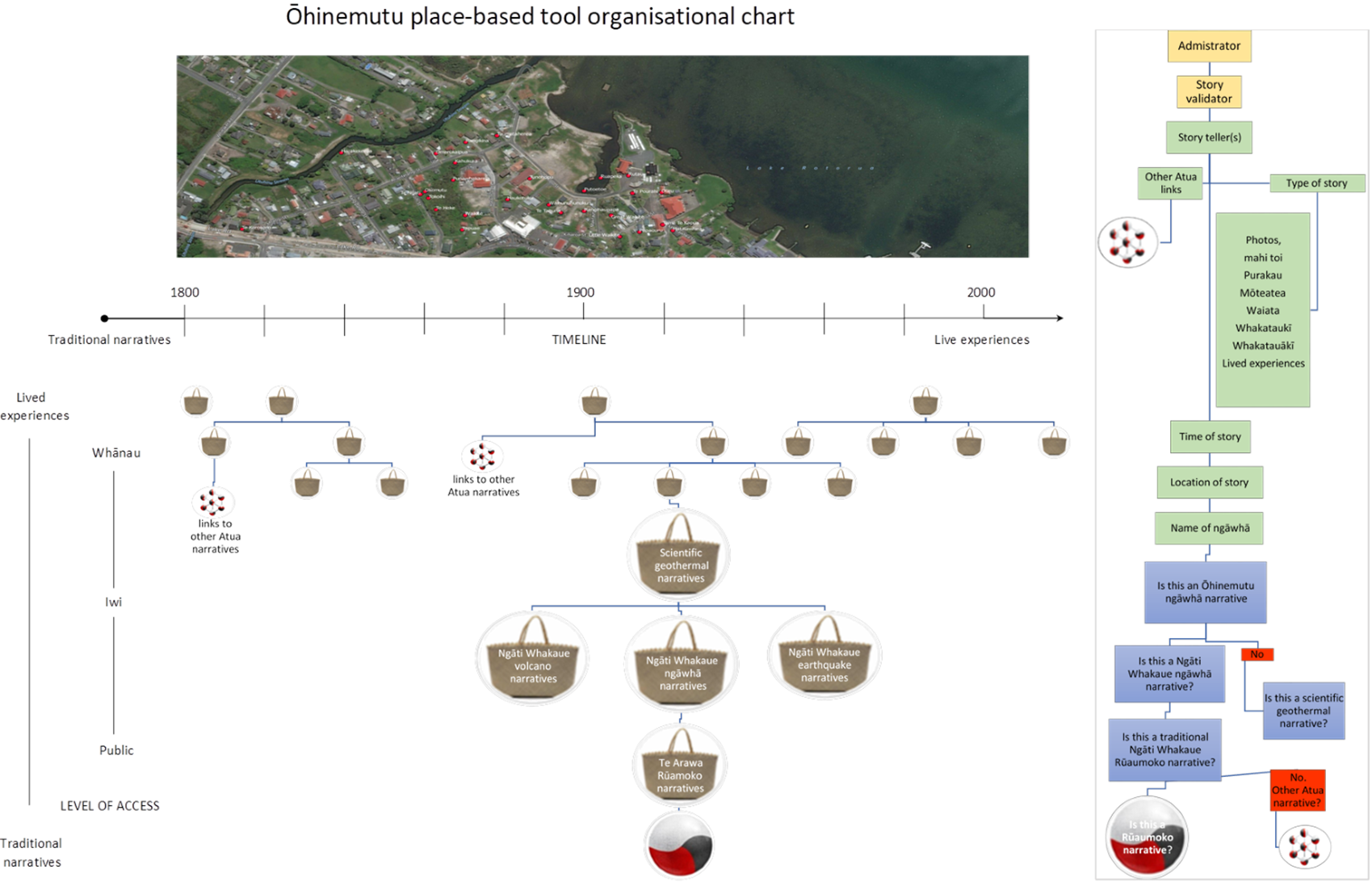
Case study 2: In partnership with Te Manatōpu Haukāinga o Ōhinemutu, supported by Te Tatau o Te Arawa, we have developed Te Kete o Kōrero ki te Ōhinemutu. This place-based web tool collates, protects and enables the sharing of local knowledge collectively held by Ngāti Whakaue and the people of Ōhinemutu Village.
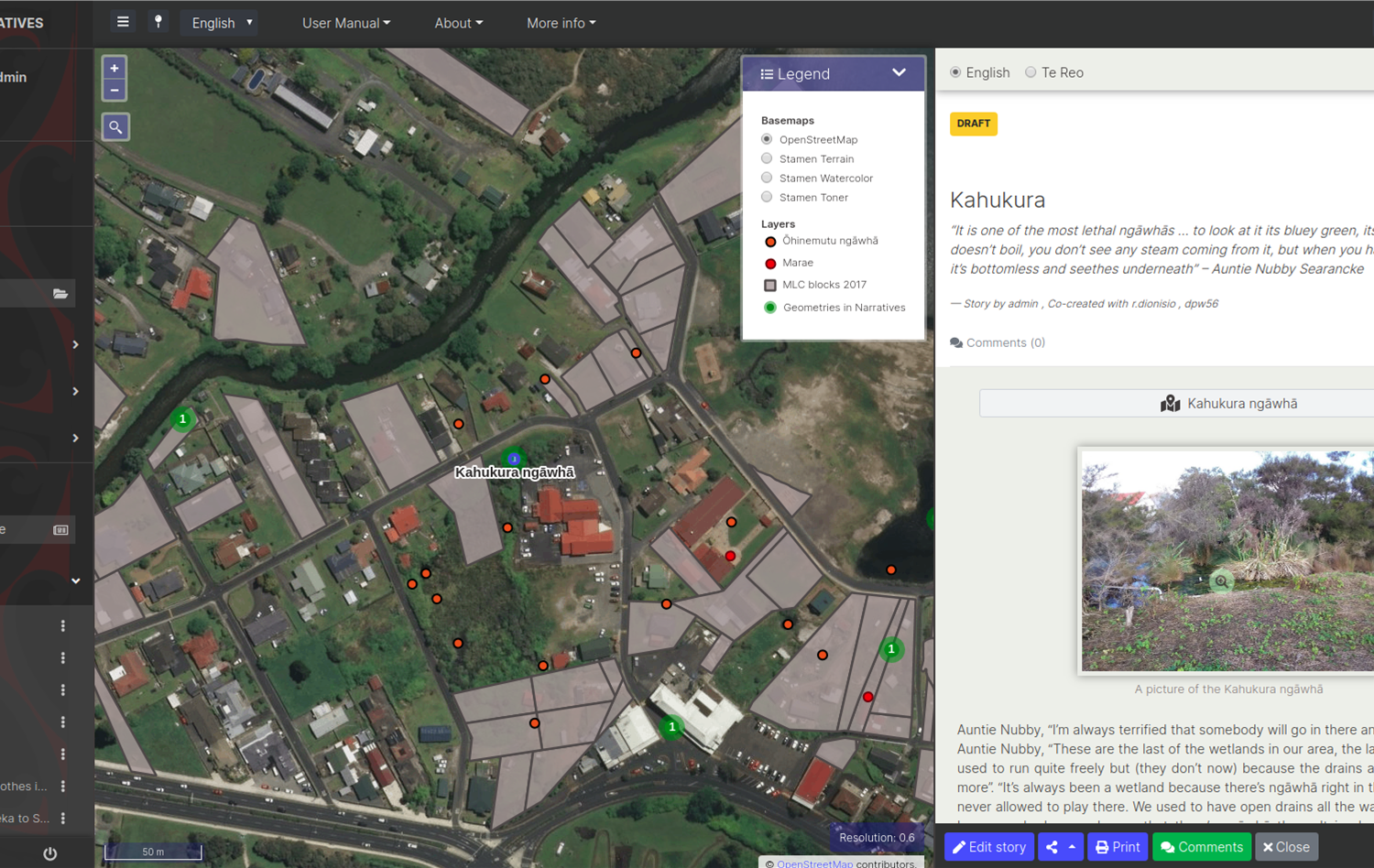
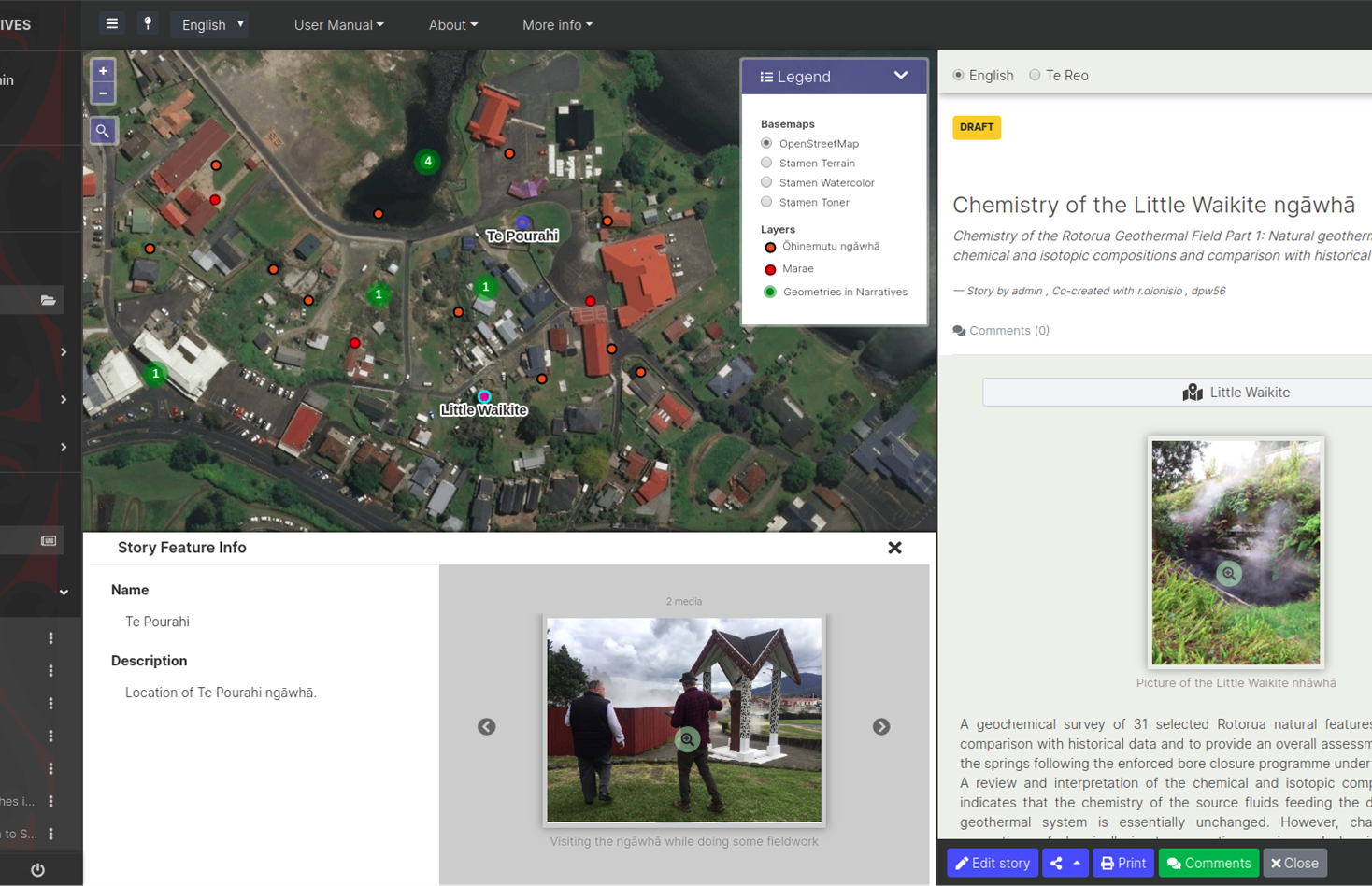
The research initially focussed on gathering cultural narratives about ngāwhā (geothermal phenomena and landscapes) and their relationships with the community. However the tool has been designed to hold other mātauranga within other realms of knowledge. These narratives are organised through koromātua (sub-tribe), type (including traditional, planning, Treaty, lived experiences, historical and scientific narratives), and through Atua (seven key spiritual guardians).Te Kete o Kōrero o Ōhinemutu will assist community led urban regeneration of the village. The cultural narratives contained in the tool will guide decision-making around spatial planning. The tool will link the community to multiple end-users (e.g. wider whānau, local planning authorities, public, etc.) and enhance awareness of the wealth of mātauranga within Ōhinemutu village and Ngāti Whakaue. The tool takes a layered approach to privacy and the protection of IP, with different levels of access and detail for tool users – public, koromātua, and whānau. Connecting mana whenua, local communities and planning authorities through place-based mātauranga is crucial to ensure bicultural approaches to urban regeneration.
Research Outputs
Dionisio MR. and Kingham SP. (2017) Immersed Engagement: A new approach to collaborative planning in Aotearoa – New Zealand. Bogota, Columbia: 23rd International Sustainable Development Research Society Conference, 14-16 Jun 2017. (Conference Contributions – Published)
Dionisio MR., Kingham SP., Glackin S. and Bristow D. (2017) Immersed stakeholder engagement: A new dimension to collaborative urban planning. (Journal Articles)
Kingham SP., Banwell K., Dionisio. and Wiki J. (2017) Benefits of and barriers to creating healthy and active urban environments. University of Otago, Dunedin, New Zealand: Active Living and Environment: Towards a Healthier and More Sustainable Future, 28-30 Aug 2017 (Conference Contributions – Other)
Dionisio R., Walker D., Macfarlane A., Kingham S., Matunga H., Kahila-Tani M. (2018). Bicultural urbanism in Aotearoa New Zealand: Place-based tools for community & rūnanga-led urban transformation. Urbanism New Zealand Conference, Wellington, New Zealand. May 2018.
Dionisio R., Schindler M., Kingham S., Falcao I. (2018). Geospatial tools enhancing local governance & community engagement in urban regeneration. International Geographical Union (IGU/UGI) Conference. Lisbon, Portugal, September 2018.
Dionisio R., Walker D., Macfarlane A., Kingham S., Matunga H., Kahila-Tani M. (2018). Cultural mapping, local knowledge and community narratives in urban planning. International Geographical Union (IGU/UGI) Conference. Lisbon, Portugal. September 2018.
Dionisio R., Walker D., Pani J. (2019). The necessity of place-based bicultural tools in Aotearoa New Zealand’s Town Planning. New Zealand Planning Institute, Napier, April 2019.
Dionisio R. and Walker D. (2019). Lessons from Aotearoa New Zealand’s Culturally Responsive Urban Planning. Royal Geographic Society, London, August 2019.
Walker D., Pani J., Mitchell A. (2019). Geospatial tools for community and rūnanga led planning. Place19 (Māori GIS) Rotorua, November 2019.
Falcão I., and Savarimuthu S. (2019). Map-based tools for Māori communities. FOSS4G SotM Oceania, Wellington, November 2019.
Dionisio R., Walker D., Caldwell R., Tirikatene C., Pani J., Waru, R., Macfarlane A., Matunga H., and Kingham S. (2020) ‘Place-based tools for Bicultural Planning in Aotearoa New Zealand’. International Indigenous Research Conference | Ngā Pae o Te Ao Māramatanga, 18-20 Nov 2020, virtual conference, Auckland, New Zealand.
Dionisio R., Walker D., & Caldwell R., (2020) ‘The development of methodologies and tools to support Māori communities in urban regeneration and recovery.’ New Zealand Geographical Society Conference, Wellington, November New Zealand Geographical Society Conference, Wellington, November, 2020.
de Jesus Dionisio R., Schindler M. and Kingham S. (2020) Tools for sustainable change: How spatial decision-support tools support transformative urban regeneration. International Journal of E-Planning Research 9(2): 21-42. http://dx.doi.org/10.4018/IJEPR.2020040102.
de Jesus Dionisio MR., Macfarlane AH., Walker DP., Macfarlane SL., Derby M., Caldwell R., Pani J. and Waru R. (2021) Ngā Mātāpono e Rua: Stories of co-creation for bicultural spatial governance in Aotearoa New Zealand. New Zealand Geographer 77(2): 76-89. http://dx.doi.org/10.1111/nzg.12299. (Journal Articles)
Dionisio R. and Macfarlane AH. (2021) Tikanga rua: Bicultural spatial governance in Aotearoa New Zealand. New Zealand Geographer 77(2): 55-62. http://dx.doi.org/10.1111/nzg.12303. (Journal Articles)
Schindler M. and Dionisio R. (2021) A framework to assess impacts of path dependence on urban planning outcomes, induced through the use of decision-support tools. Cities 115 http://dx.doi.org/10.1016/j.cities.2021.103256. (Journal Articles)
Media
He Pito Mata, Dionisio R. and Walker D., (2020) Common Ground, promotional video, Kaiapoi, Aotearoa New Zealand.
Ngāti Whakaue, Te Tatau o Te Arawa, Dionisio R., Walker D. and Macfarlane A. (2020) Te Kete Kōrero o Ōhinemutu, promotional video, Rotorua, Aotearoa New Zealand.
Dr Rita Dionisio, Dr Dean Walker, Dr Sharmila Savarimuthu have launched two web-based tools which were co-created with Ngāi Tūāhuriri and Ngāti Whakaue.

