Date
2022
Authors
Matthew Wilson, Delwyn Moller, Sharmila Savarimuthu, Xander Cai, Chris Ruf
Abstract
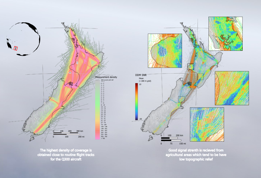
In a unique partnership, the Rongowai (“sensing water” in te reo Māori) airborne remote sensing mission comprises of a next-generation Global Navigation Satellite System Reflectometry (GNSS-R) receiver (NGRx) mounted on a domestic Air New Zealand Q300 aircraft. The sensor captures reflected GNSS “signals of opportunity”, building on the legacy of novel space borne missions such as CyGNSS (Ruf et al. 2012), and providing valuable data for the development of future missions such as HydroGNSS. During the aircraft’s routine scheduled operations, Rongowai autonomously records reflected GNSS signals, then transmits data via a cellular connection once the aircraft has landed. The L-band GNSS radio signals which are reflected from the land surface are sensitive to soil moisture (Kim and Lakshmi, 2018) and surface water (Gerlein-Safdi & Ruf, 2019), providing a valuable additional source of data for the terrestrial hydrosphere. Rongowai is enabling unprecedented high spatiotemporal resolution surface water and soil moisture estimates across New Zealand’s diverse landscapes. Here we present our progress towards the development of algorithms for soil moisture estimation using Rongowai data.
Building from our previous work using CyGNSS data at a near-global scale (Datta et al. 2022), we developed a machine learning framework for the rapid processing of Rongowai science data (L1), with the aim of producing soil moisture data products. The framework assimilates multiple sources of satellite or airborne remote sensing data as predictors, with soil moisture measurements from in-situ gauges used for training and testing. A random forest algorithm is used with predictor variables including terrain indices based on high resolution LiDAR (slope, topographic wetness index and height above nearest drainage), forest heights derived from NASA GEDI, vegetation greenness using NDVI from MODIS, Copernicus Global Land Cover, antecedent weather conditions using precipitation observations from GPM, surface soil mineralogy from FAO SoilGrids, and soil saturated hydraulic conductivity. Predictor variables are used along with polarimetric delay Doppler map data to predict soil moisture for each observation location at high resolution. In further work, a multi temporal gridded data product will be created to facilitate use by stakeholders.
Click to view or download the PDF of the poster.