
Geospatial Research Seminar Series (GRISS) – 27 November 2020
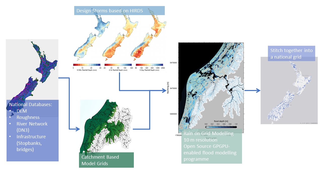
Flooding is Aotearoa/New Zealand’s most frequent hazard and its impact will only increase under climate change through both more intense rainfall events and sea level rise. We are currently going through a massive flooding infrastructure revamp as well as investing in significant urban development. However, we don’t yet have a consistent national understanding of what our flood risk is now – let alone in the future.
Geospatial Research Seminar Series (GRISS) – 25 September 2020 (online & in person)
Prof Sabel is a spatial data scientist working in the nexus between health and spatial data informatics. He is Director, BERTHA – Big Data Centre for Environment and Health at Aarhus University, but previously worked at the University of Canterbury, Department of Geography as a GISc lecturer. The BERTHA Big Data Centre for Environment and Health at Aarhus University, Denmark, aims to muster the huge potential opportunities from the Big Data revolution to help us understand the complex interactions between environmental pollutants and human health.
Senior Lecturer and research fellow at the GeoHealth Laboratory Dr Matthew Hobbs gives an Author Q&A Research Insight by the British Dental Journal

The article, Investigating the prevalence of non-fluoride toothpaste use in adults and children using nationally representative data from New Zealand: a cross-sectional study, of which Dr Hobbs is the first author, has already been highlighted in the local media and oral health research sector. The full Q&A of Dr Hobbs by the BDJ can […]
Senior Lecturer and research fellow at the GeoHealth Laboratory Dr Matthew Hobbs makes the news talking about his research in the prevalence of non-fluoride toothpaste use in New Zealand
See Dr Hobbs interview at Breakfast morning news show here: https://www.facebook.com/337418942718/posts/10157902159217719/?vh=e&d=n You can also access his related research publication at: https://www.nature.com/articles/s41415-020-1304-5
GEOSPATIAL RESEARCH SEMINAR SERIES (GRISS) – 25 October 2019

The Geospatial Research Institute is pleased to host Dr Kat Salm. Kat has been working in the spatial industry in New Zealand across government, industry, and research/education for a number of years. She is also the winner of the 2018 New Zealand Spatial Excellence Awards (NZSEA) in the category “Women’s Leadership Award”, as well as the 2019 Asia-Pacific Spatial Excellence Awards (APSEA).
GEOSPATIAL RESEARCH SEMINAR SERIES (GRISS) – 27 September 2019
Regional Councils collect a lot of environmental data. We’re good at it and it is hugely valuable to our policy decisions and general environmental management. A recent valuation of the Environment Canterbury hydrological database was $4.2 billion, based on a mixture of the collection costs and the value of decisions made with those data. With all that data comes the challenge of data management and more importantly; how to tell a coherent story of “what’s going on”. This seminar will set out the types of data collected by Environment Canterbury and discuss possibilities for telling environmental stories in a better way.
GEOSPATIAL RESEARCH SEMINAR SERIES (GRISS) – 26 July 2019
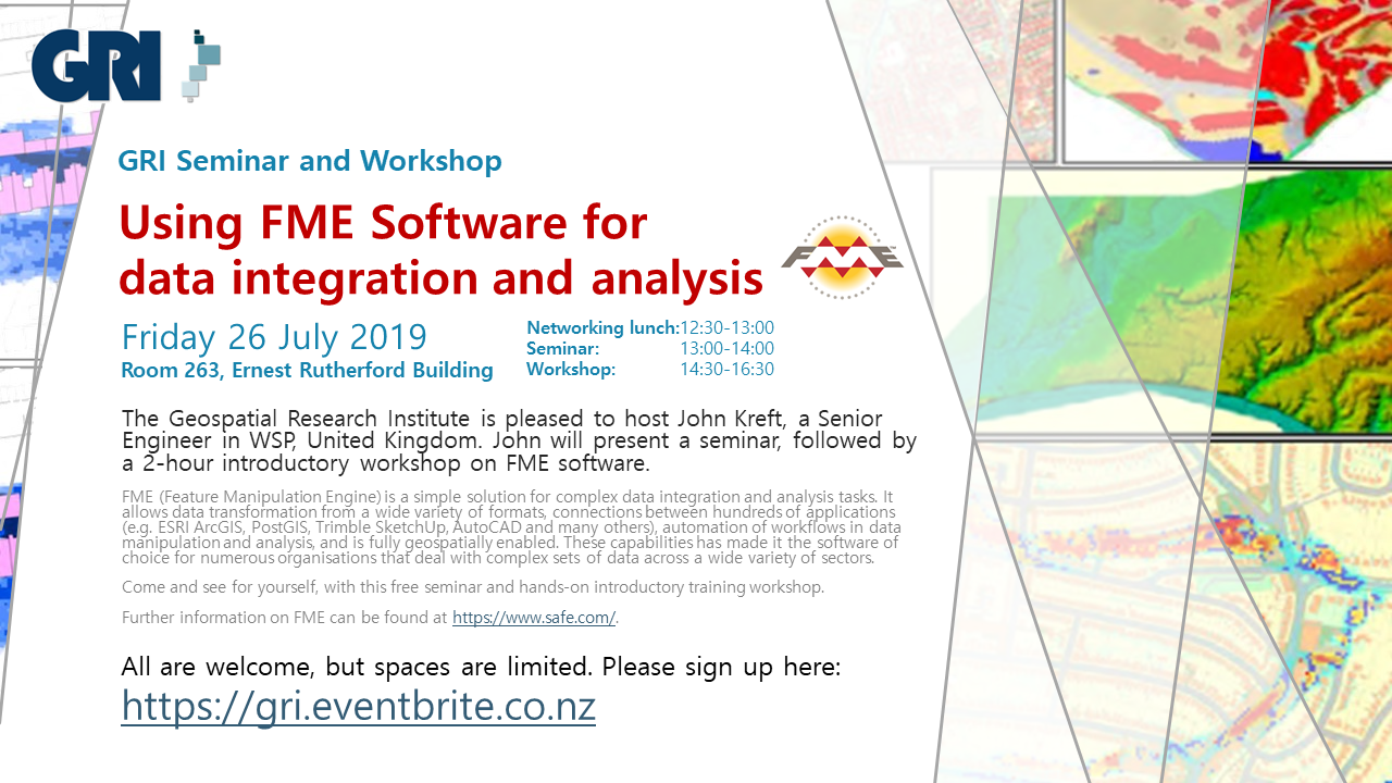
FME (Feature Manipulation Engine) is a simple solution for complex data integration and analysis tasks. It allows data transformation from a wide variety of formats, connections between hundreds of applications (e.g. ESRI ArcGIS, PostGIS, Trimble SketchUp, AutoCAD and many others), automation of workflows in data manipulation and analysis, and is fully geospatially enabled. These capabilities has made it the software of choice for numerous organisations that deal with complex sets of data across a wide variety of sectors.
GeoHealth Lab Seminar, 25 May 2019: A multidisciplinary perspective on environmental determinants of lifestyle and health
Please come along to see Dr. Joreintje Mackenbach-van Es from the Amsterdam UMC present her seminar on the environmental determinants of lifestyle and health. Abstract There is widespread consensus that our environment affects our behaviour and health, but less understanding of how this works. I will mainly focus on food and physical activity environments, but […]
GEOSPATIAL RESEARCH SEMINAR SERIES (GRISS) – 28 June 2019
Dr John McCarthy is a Principal Technical Specialist within the Health & Disability Intelligence Group at the Ministry of Health (MoH). In this talk John will be discussing the capability and capacity for geospatial analysis at the MoH, and how geospatial evidence contributes to policy formation and Government priorities. A current project, the development of an Atlas of Cancer Variation for New Zealand, will be presented as a working example.
Submissions open: NZ Geospatial Research Conference 2019
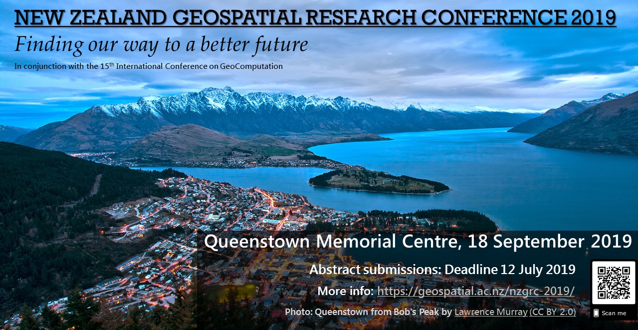
Kia ora koutou katoa, We are pleased to announce that abstract submissions are now open for the 2019 New Zealand Geospatial Research Conference. We invite you to join us at the Queenstown Memorial Centre in beautiful Queenstown, Otago on 18 September 2019 and present your geospatial research. Please submit your abstracts of no […]