PhD student:
Martin Nguyen (PhD student, UoC)
Supervisors:
Matthew Wilson (Main Supervisor, UoC)
Emily Lane (Supervisor, Earth Sciences NZ)
James Brasington (UoC)
Rose Pearson (Earth Sciences NZ)
Funding:
MBIE Endeavour Research Programme – Increasing flood resilience across Aotearoa, New Zealand
Summary:
Uncertainties inherent in the flood modelling process, especially in the input data, can affect flood predictions, reducing reliability of flood risk management plans. To increase the reliability and contribute to the field, this thesis has quantified two sources of uncertainties in the generation process of Digital Elevation Models (or DEMs), a critical input for flood modelling, using the traditional Monte Carlo framework. Apart from that, since such uncertainty quantification processes are often excluded from the flood risk assessment owing to being computationally expensive, this thesis has developed an advanced method for quantifying such uncertainties using a machine learning approach.
Methods
Monte Carlo framework and Deep learning models
Results
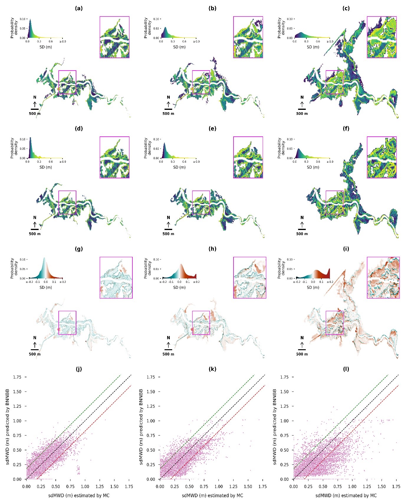
A Bayesian Neural Network has been developed to predict the uncertainty in flood modelling arising from uncertainties in the topographical bathymetric data generation process.
*Caption: The above figure shows the comparison of maps of the standard deviation of maximum water depths (sdMWD) for the January-20005 flood event occurred at the Waikanae River, Wellington. These maps were estimated by the Monte Carlo framework and predicted by the Bayes Neural Network (BNN) with transfer learning technique. The first, second, and third columns represent sdMWD maps at 5-, 10-, and 20-m resolutions, respectively: (a-c) maps estimated by the MC framework, (d-f) maps predicted by the model BNN, (g-i) difference maps between MC framework and the model BNN, and (j-l) scatterplots of results of these two methods – green and red dash lines are boundaries of over- and under-predictions (difference values are >= -0.1 m and <= 0.1 m), black dash line represents the equality of the MC estimates and predictions from the model BNN.
Outputs:
Nguyen, M., Wilson, M., Lane, E., and Brassington, J., Uncertainty in Predictions of Flood Inundation Caused by Model Grid Sampling: AGU Fall Meeting 2022, Chicago, 12-16 December.
Nguyen, M. Uncertainty in bathymetry estimation. The Fourth Spatial Data Symposium, Christchurch, Sept 5-6, 2023. Poster.
Nguyen, M., Wilson, M., Lane, E., Brasington, J. and Pearson, R. Uncertainty in Flood Predictions Caused by River Bathymetry Estimation. AGU23. San Francisco, December 12, 2023.
Nguyen, M., Wilson, M. D., Lane, E. M., Brasington, J., & Pearson, R. A. (2025). Quantifying uncertainty in flood predictions in fixed Cartesian flood model due to arbitrary conventions in grid alignment. Water Resources Research, 61, e2024WR038919. https://doi.org/10.1029/2024WR038919
Nguyen, M., Wilson, M. D., Lane, E. M., Brasington, J., & Pearson, R. A. (2025) Estimating uncertainty in flood model outputs using machine learning informed by Monte Carlo analysis. Journal of Hydrology, Vol 662, Part C. https://doi.org/10.1016/j.jhydrol.2025.133928