Research team
Matthew Wilson (GRI – UoC)
Shin-Chan Han (UoNC, AU)
Mehdi Khaki (UoNC, AU)
In-Young Yeo (UoNC, AU)
George Townsend (UoNC, AU)
Fang Yuan (FrontierSI, AU)
Martin Nguyen (GRI – UoC)
Xaiodong Cai (GRI – UoC)
Duration of project
2024-2025
Funding
Australia New Zealand Collaborative Space Program (Catalyst Fund and SmartSAT)
Summary
Irrigation exploits most of agricultural use of water, consuming more than half of the total water in Australia and New Zealand. Given the size of water use in irrigation, using more efficient water management will lead to a great impact on freshwater resources. Soil moisture probes are widely used in irrigation, but sampling is only available “point-wise”, not necessarily representing the overall water need over fields. To measure soil moisture comprehensively, our joint research exploits the L-band microwaves reflected off land surface and ubiquitously available from the GNSS constellation. This project integrated Global Navigational Satellite System (GNSS) remote sensing measurements of soil moisture from several platforms of satellites, aircraft and ground receivers. The study provided baseline information for exploiting remote sensing data to provide spatial and temporal variations of soil moisture at field scales through development of the soil moisture data assimilation system. In particular, the system’s outputs aimed to be appropriate to local water resource management and decision making for agricultural practices and environmental applications.
This research is leveraging established sites where in-situ soil moisture measurements have already been gathered in Australia and New Zealand, to verify GNSS land reflection measurements from NASA’s CYGNSS satellites, New Zealand’s Rongowai aircraft, and University of Newcastle’s ground GNSS remote sensing module. We performed extensive comparisons among satellite and aircraft GNSS reflectometry measurements, ground GNSS reflection records, and in-situ probes for verifying soil moisture changes at field scales.
This feasibility study was the first of its kind to put all GNSS remote sensing systems together to make satellite-airborne-ground co-located GNSS experiments for soil moisture retrieval. The field campaigns enabled us to validate GNSS-based remote sensing sensors for monitoring soil moisture under real-world conditions; and to ensure that the sensing systems are tested across a range of climates, soil types, and terrains to optimize the sensor performance for various agricultural and environmental use cases.
The GNSS signal’s reflectance changes with soil moisture content and is sensitive to wider areas in contrast to point-wise ground probes. These are early results from cross-validation of three GNSS remote sensing systems from satellite (CYGNSS), airborne (Rongowai), and ground-borne sensors, which work in the identical principle but at different resolutions and coverages. In this research, we conducted field campaigns of co-located experiments and extensive calibration and validation of three different types of GNSS-based soil moisture data.
Our successful field calibration and validation (Cal/Val) of GNSS measurements is now leading to the development of the Soil Moisture Data Assimilation System (SMDAS), funded by an MBIE Catalyst grant starting in 2026. The SMDAS can be a game changer of integrating efficient GNSS-based remote sensing measurements with imaging radars and radiometers to retrieve soil moisture information adequate to farmers, practitioners, and governments, to save water for efficient and drought-resilient agricultural and farming practices
Field campaigns
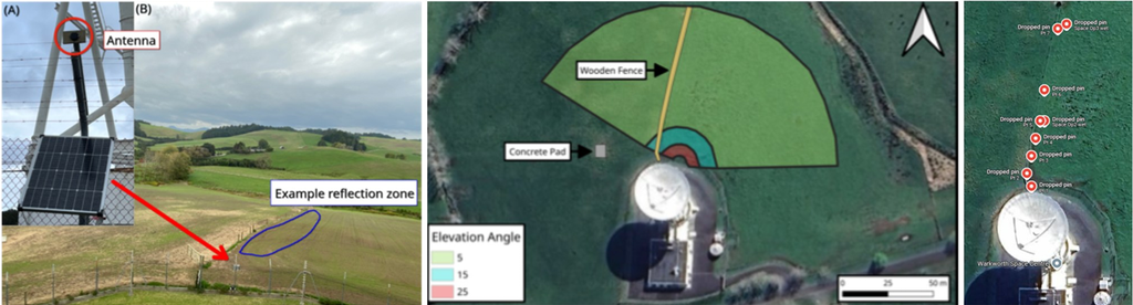
A proof-of-concept GNSS-IR ground station installation system was constructed using Commercial Off-The-Shelf (COTS) components, including a Raspberry Pi single-board computer, u-blox ZED-F9P multi-band GNSS receiver, 4G LTE modem for data telemetry, housed within a custom weatherproof enclosure and powered by a solar panel and battery system. Open-source software solutions were configured for data acquisition, system management, and remote access. The system operating autonomously since installation in April 2025 until the end of the project. The onboard RTKBase software logs raw GNSS data hourly.
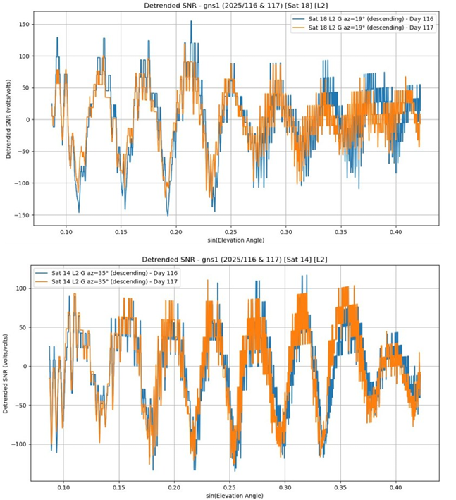
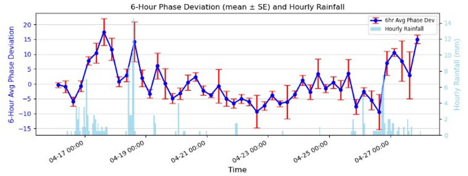
Left: ‘Raw’ data of GPS-IR waveform from two example GPS satellites before (top image: day 116/April 26, blue) and after (bottom image: day 117/April 27, orange) rainfall. The rainfall causes a phase-shift (or equally wavelength shortened) in GPS-IR waveforms for signals received at the same location.