Project leaders
Georgina Dawson (Māori Impact Manager – ESR)
Matthew Wilson (University of Canterbury)
Russleigh Parai (Māori Impact – ESR)
Funding
Institute of Environmental Science and Research Limited (“ESR”)
Project summary
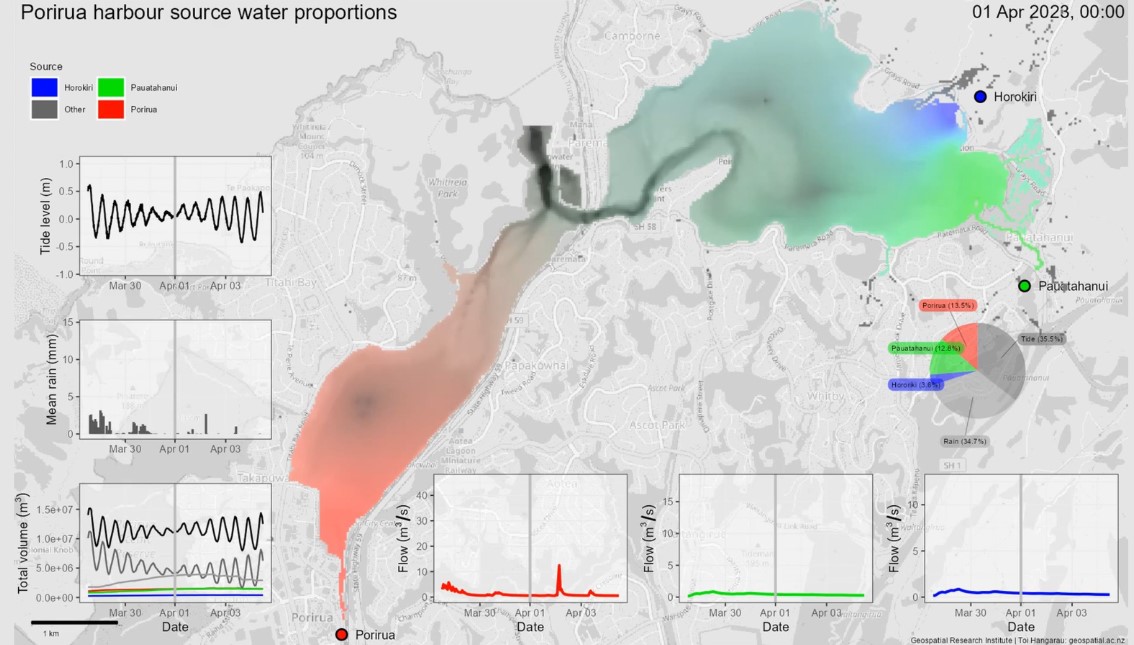
A flow model of the Porirua Harbour with water source tracing capability was developed to enable an assessment of where is likely to be most affected by fluvial pollutants and assess the tidal flushing of the harbour. The model was developed and is available under open-source licensing. By using the model to assess where in the harbour is affected by which contributing water source, and by how much, results from the model can be used to infer where fluvial pollutants are likely to be within the harbour.
As part of the model developments and analysis, a seamless topography-bathymetry grid suitable for hydraulic modelling was developed, observations of river flow, tide level and rainfall were obtained and processed, and the flow tracing model was constructed using open-source CAESAR-Lisflood 2.0 software. The model was run for a 1 year period (2023) and, in addition two scenarios representing the potential impacts of sea level rise on water source mixing in the harbour were assessed.
Model results indicate that the proportion of river water in the harbour increases at low tide and after rainfall events in the river catchments, and that water from each non-tidal source tends to accumulate in the harbour, particularly in the upper harbour inlets and along the shorelines, as it is pushed back by the incoming tide. Since the river water carries with it pollutants from the catchments, results indicate that the locations within the harbour most likely to be affected by this are the shorelines along the upper harbour inlets. The sea level rise scenarios suggest an increase in fluvial source depths in the upper reaches at both low and high tides, with higher source depths for higher increases in sea level, which would likely worsen the situation regarding pollutants.