Research team
Xander Cai (GRI– UoC)
Matthew Wilson (GRI– UoC)
Funding
GRI funds
Duration
2023
Project summary
A Digital Elevation Model (DEM) stores and represents elevation as an image raster, widely used as fundamental data for research, applications and policy decisions related to land and earth. DEMs can be classified into the Digital Surface Model (DSM) and Digital Terrain Model (DTM). A DTM represents the elevation of the bare ground, while a DSM represents the elevation of the highest objects on the ground, which could be a tree or a building. In recent years, Light Detection and Ranging (LiDAR) based on airborne become popularly used to create high-resolution and high-accuracy DTMs because it can distinguish, classify, and remove objects on the ground from the survey data. Spaceborne sensors such as Synthetic Aperture Radar (SAR) and stereoscopic imaging are used to generate coarse resolution (1 arc-second at best, around 30 meters at the equator) global DSMs, more precisely, approximate DSMs due to penetrating vegetation to various degrees.
Although modern measurement technologies can quickly obtain elevation information and provide DEM products for the public, freely available global DEMs are limited in their resolution, accuracy and coverage. Therefore, it is a common practice to generate high-resolution DEMs using the Super-resolution (SR) approach for areas without LiDAR-derived high-resolution DEMs. With the presentation of Super-Resolution Convolutional Neural Network (SRCNN) in 2014, deep learning approaches started dominating the Single Image Super-Resolution (SISR) problems. Consequently, researchers developed and applied methods based on SISR approaches to the DEM Super-Resolution (SR) problems. Among the previous work, little research has been done on real-world DEM SR problems.
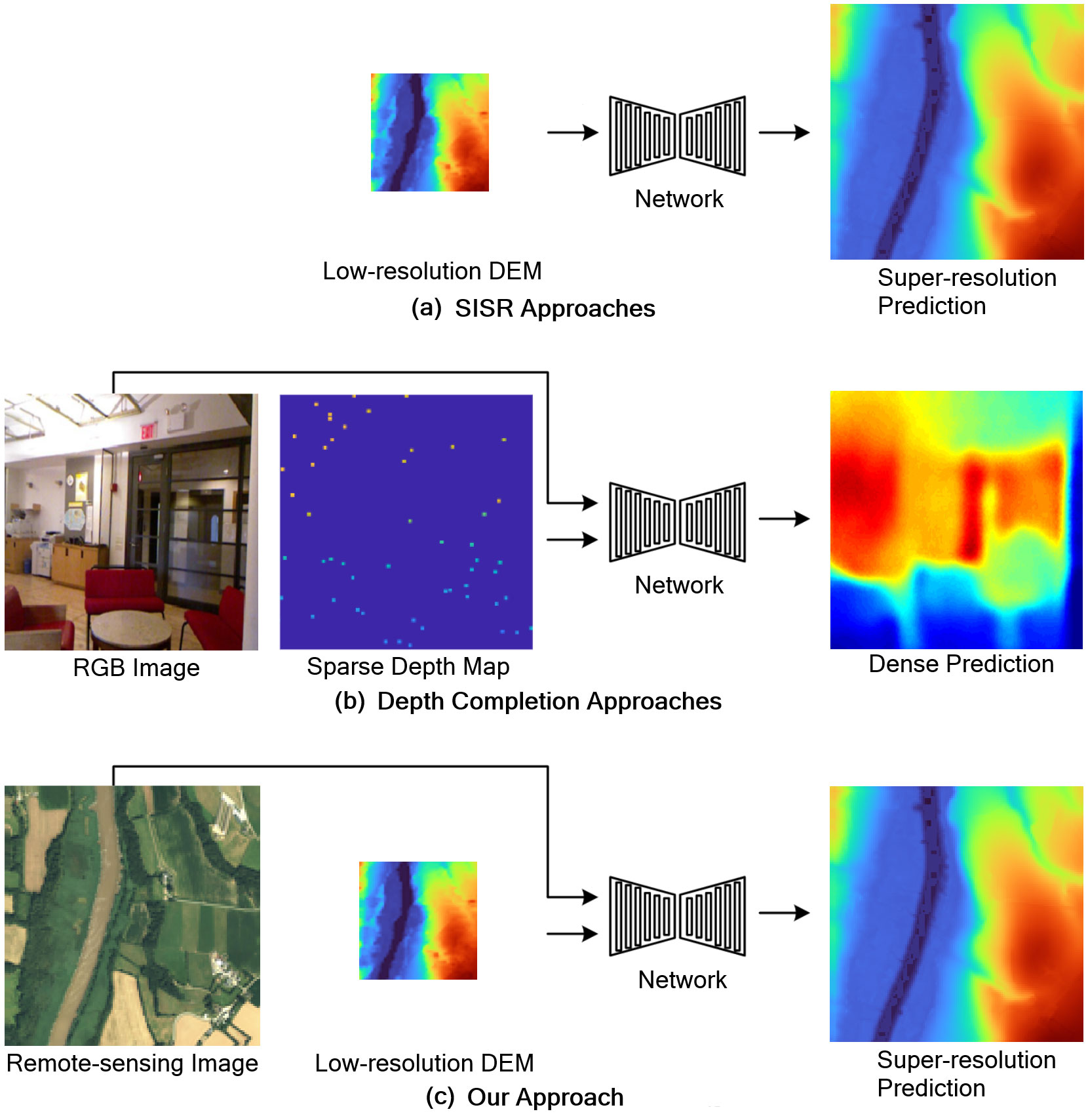
Motivated by the difficulties for real-world DEM SR based SISR approach, we investigates real-world DEM SR problems leveraging approaches for sparse-to-dense depth completion problems that infer the dense depth map of a 3-dimensional scene based on its corresponding sparse depth map and a guidance RGB image. The figure outlines different approaches: the depth completion approach exploits the corresponding RGB image to guide the network for predicting a dense depth map from sparse depth maps, while the SISR approach only uses low-resolution images as input to predict SR images. Since both DEMs and depth maps represent 3-dimensional data, assuming low-resolution DEMs are sparse depth maps and high-resolution DEMs are dense ground truth depth maps, employing depth completion approaches to solve DEM SR problems as Figure (c) shown is a promising approach.
In this project, we propose a novel approach for DEM super-resolution that learns non-local weight and offset from fused guidance features to correct errors in the low-resolution DEMs and predict super-resolution DEMs. Our method improves accuracy (RMSE) by over 56%/38% and reconstruction quality (PSNR) by over 9%/4% on 8-meter resolution and 3-meter resolution datasets compared to Bicubic/EDSR. We also propose a dataset for DEM super-resolution based on publicly accessible datasets with high-resolution aerial images, semantic segmentation masks, DEMs, and low-resolution DEMs. This dataset can be used as a benchmark for real-world DEM super-resolution problems to compare different algorithms’ performance straightforwardly.