

Predicting the abundance and the likely persistence of New Zealand top mammalian predators
Research Team:
Audrey Lustig
Micael Plank
Alex James (University of Canterbury, Te Pūnaha Matatini)
Collaborators:
Dean Anderson (Manaaki Whenua)
Funding Sources:
Te Pūnaha Matatini
The Geospatial Research Institute Toi Hangarau,
Manaaki Whenua Landcare Research
Hawke’s Bay Regional Council
Length of the project:
03-2017 to 03-2020
Summary:
Pest are everywhere, from urban gardens to national parks, but agreeing how to control them is not always straightforward. One third of new Zealand’s land area is classified as protected, but still, large portions of land are privately owned, and the conservation effort is, relatively, a low priority. When it comes to land management decisions such as pest control actions, careful negotiations are required with a wide range of stakeholders with differing views and expectations – from cat-lovers to rabbit-haters – which can influence their engagement and participation in pest management practices. Yet, these individual behavioral aspects are seldom modelled in environmental management despite the fact they may drive the success or otherwise of environmental management.
In March 2017, Audrey Lustig began a three-year postdoctoral research fellowship funded by Te Pūnaha Matatini data analysis Centre of Research Excellence in Auckland and the Geospatial Research Institute.

Working with Assoc. Prof Alex James and Prof. Mike Plank, she developed a social-ecological model that allow for human and ecological systems to be linked and scenarios tested to help predict their influence over each other and improve pest management practices. Such modelling can help predict the abundance and the likely persistence of New Zealand top mammalian predators in the light of potential changes in management efforts across human-dominated landscapes and can be used to formulate a management regime that is most likely to achieve eradication.
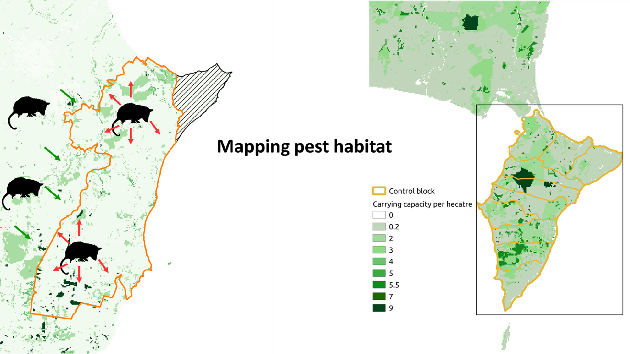
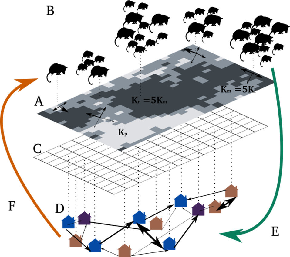
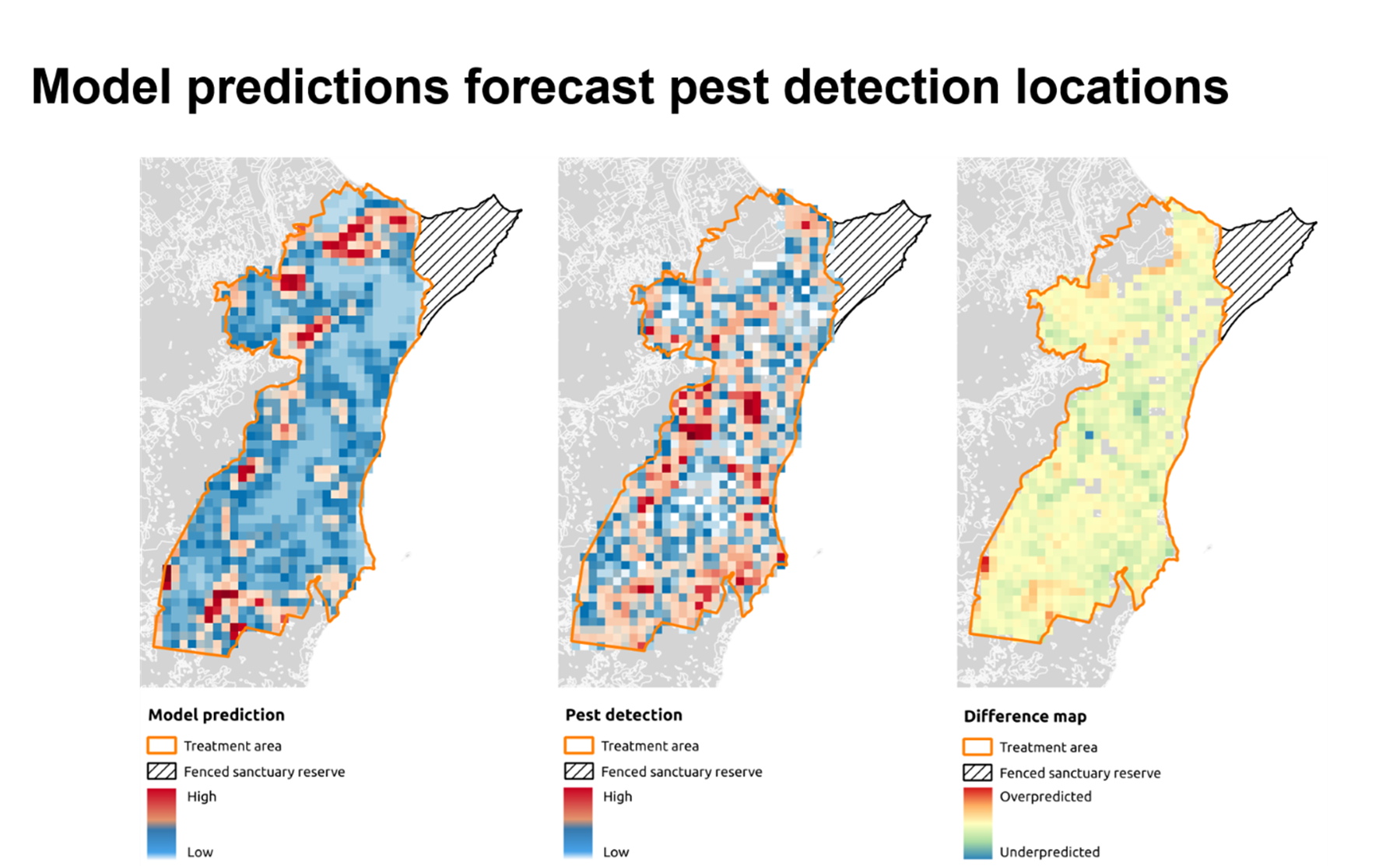
Research for 2017/2018 primarily focused on developing the ecological aspects of the model. A key contribution of this work has been the integration of a more sophisticated representation of species-habitat interactions into a generic model of spread to create dynamic maps showing future population trajectories. The model describes the behavior of individual mammals located explicitly in a map of their habitat. Key events in an individual’s lifetime comprise birth, death, and dispersal, and these are simulated as stochastic, i.e. there is uncertainty in the timing of each event. Such modeling provides detailed forecasts of mammal abundance at regular time intervals into the future. Data are colour-coded so that areas of high and low mammal density are easily distinguished.
The approach developed is based on combining generic mathematical modelling frameworks with spatial information on habitat distribution, population dynamics and actual levels of control. Therefore, the approach could be applied to a variety of medium size mammalian pests. In addition, the model allows exploration of how the distribution and abundance of mammals can be affected by control interventions by landholders. Important roles for this type of model are to help predict hotspots of mammalian pest activities, to suggest the most effective control strategy, and to identify important parameters and data for improving predictions.
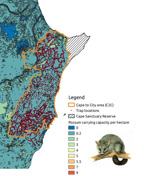
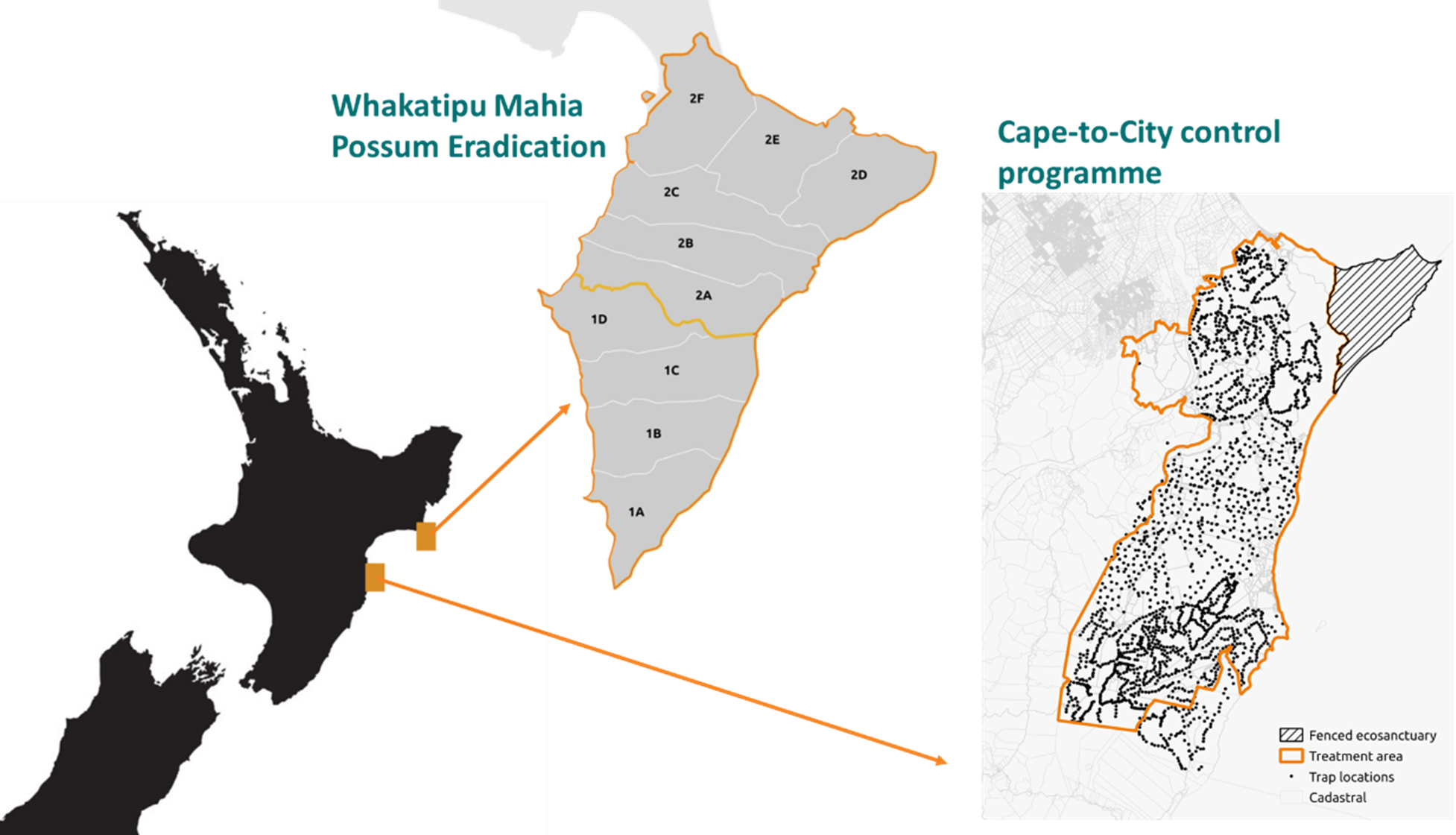
The common brushtail possum (Trichosurus vulpecula) population across a geographically large treatment area in Te Matau a Māui/ Hawke’s Bay, New Zealand was used as a case study. The predator management effort in this area is coordinated by the Cape-to-City programme, a multi-agency initiative that aims to evaluate the economic and ecological consequences of large-scale, low-cost predator control in rural and peri-urban landscape The programme involves controlling possums, as well as other mammalian pests, across 26,000 ha of predominantly private land in the Hawke’s Bay region. This is the start of a much more ambitious project to eliminate mammalian pests from the entire country. As part of the campaign to suppress possums in the Cape-to-City treatment area, intensive monitoring efforts have focused on better understanding the spatiotemporal patterns of abundance and spread of the species.
The research team investigated the effectiveness of different spatial and temporal distributions of trapping effort in the treatment area and highlighted important findings for assessing the effectiveness of a pest control operation. First, there are striking differences in the effectiveness of spatial control strategies – a well-designed spatial control strategy could be up to twice as cost effective as poorly designed ones. Second, the optimal spatial strategy may depend on the total control effort. Third, for some species, e.g. the brushtail possum which has a predominantly annual reproductive strategy and relatively constant capture probability over time, control timing has only a minimal effect. Fifth, immigration rather than in-situ breeding is likely to initiate the population recovery in treated areas after an initial knockdown. Therefore, increasing the size of treatment areas and maximizing the use of natural barriers to immigration could prolong treatment persistence.
The spread model was developed to provide more functionality for managers. In particular, investigating the ways in which landholders influence one another, how agencies influence landholders, and the presence of key influential landholders who might help catalyze actions are the current focus of research. Dr. Yletyinen (University of Canterbury) has extracted social drivers to collective rural conservation in New Zealand using Dr. Brown’s data (Manaaki Whenua) from the 2015 and 2018 National Surveys of Rural Decision Makers. She is incorporated the social data into analytical processes within a theoretical social-ecological model including social networks and landscape-scale conservation. Working in collaboration with Dr. Yletyinen we will adapt the social-ecological modelling already developed to better understand the human-nature relationship and feedbacks as influencing factors of landowner participation in predator control in New Zealand. The work builds on a pre-existing knowledge base and data acquired by the Hawke’s Bay Regional Council, Department of Conservation, Manaaki Whenua and the Biological Heritage Challenge. Such inter-organisational joint effort is common in New Zealand; for the research team, this partnership has brought a more practical insight into the research. Ultimately, the aim of the model is to improve strategic planning for mammal control at regional scales. In addition, this model serves as a template for future dynamic map of other mammal species.
In early 2019, Audrey joined the Manaaki Whenua – Landcare Research Wildlife Ecology and Management team to implement her modelling framework in the context of supporting the Predator Free NZ programme, that aims to eradicate New Zealand’s most damaging introduced predators. This project involves collaborative interactions with several predator control projects across the country, some of which sponsored her current research activities to bring practical improvements in pest management in New Zealand and abroad.
One method commonly used to eradicate an open population of mammalian pest is the deployment of control and monitoring devices across the landscape. This method selects appropriate baits, lures and trap types, as well as device placement sites and timing of control for effective exposure of every individual pest to a control item. A one-size-fits-all strategy does not exist. Instead, managers need to be able to adapt plans to take advantage of local geography and emerging technologies. Therefore, managers require flexible tools to analyse whether the necessary conditions for success can be met: can all the pests be removed faster than they recover their losses? Is reinvasion unlikely or manageable? When should we start and stop control?
The modelling framework developed by Audrey can be used to test these types of questions. The model simulates spatially-explicit sub-populations of mammalian pests located explicitly in a map of their habitat, including birth, death, migration processes and probability of capture/detection to represent population responses to control. It is designed to model migration between operational areas and differing control methods and timing between areas. Important roles for this type of model are to help confirm that the proposed control device spacing and control effort can achieve elimination and help prevent reinvasion.
Control effort, numbers of animals removed, their location and age can all be measured as the elimination campaign proceeds. Such information can then be used to refine model forecast and allows managers to adapt their plans and improve their chances of eventual operational success.
For example, the model was applied to the operational plan, launched as Whakatipu Mahia, for eradicating possums on Mahia Peninsula by the end of 2021. Using existing estimates of current possum densities, carrying capacity and home range parameters, the model estimated strong declines in possum abundance, including elimination in over 90% of simulations for the first phase of the plan (south of the peninsula), but possum elimination was highly unlikely for the second phase of the plan (north of the peninsula). Modelling was able to identify operational areas likely to contain remaining possums. Based on these results, the model was used to guide the development of a control network that could achieve elimination across the entire peninsula. Control-to-zero density of possums was feasible if buffers of bait stations around high density possum operational areas and across the neck of Māhia Peninsula are used to limit immigration from untreated areas. The model also showed that possum density at the edge of the operational area has a very low effect on the suppression of possums in the operational area and did not compromise the effectiveness of the eradication plan. This is not surprising as the operational area takes advantage of the geography of the Mahia Peninsula, with a lagoon and settlement at the neck of the peninsula creating an effective natural barrier to pest immigration from uncontrolled areas. The trappability parameters (probability of detection/capture and spatial decay in the probability of detection/capture) appear to be particularly important in determining the level of trapping effort (trapping duration and strategy) needed to achieve eradication.
The modelling framework developed (released in 2019), is a freely available, open-sourced application at:
https://github.com/AudreyL/PestManagement.
Audrey organised a 6-week series of mini-seminars for a group of modellers at Manaaki whenua and AgResearch to provide hands-on experience with the new modelling approach. Since then, Cecilia Arienti has been using the tool to assess the risk of possum re-invasion into the approximately 1.5 million hectares that Horizon Regional Council undertakes control in. Audrey also co-supervised Charlotte Paterson, a masters student at Otago University, to explore the trapping layout and effort necessary to prevent reinvasion of the Otago Peninsula, which highlighted possum population trajectories and potential reinvasion pathways onto the Peninsula. She collaborated with Giorgia Vattiato, PhD candidate at University of Canterbury, to investigate the impact of inter-individual variation in the detection/capture probability on eradication outcome on the Mahia Peninsula.
In addition, quantifying the probability of elimination given negative surveillance results is also important. When a surveillance network does not detect possums across a targeted area, it does not necessarily mean absence of possums (i.e. complete removal of possums from the targeted area) but does provide some confidence in the absence of possums. Proof of absence modelling (Anderson et al. 2013) quantifies this confidence into a probability of absence based on the frequency of zero detections, conditional on the spatial arrangement of a specified surveillance network. Audrey was engaged to work with Dean Anderson, Andrew Gormley, Pascal Omondiagbe and their co-workers to organize a two-day workshop held at Manaaki Whenua – Landcare Research, in 2019. The workshop had a range of participants from different eradication projects across NZ with a strong emphasis on Predator Free 2050 projects. During the workshop, some complex statistical concepts around the Anderson’s Proof of Absence model were presented and discussed. The participants were able to run the model with their own data on a web based platform that Pascal and Audrey had recently developed, testing different operational assumptions and their impact on the Proof of Absence. For example, the workshop was used to clarify and revise the Proof of Absence model assumptions and parameters with the Hawke’s Bay Regional Council and guided the development of a surveillance network to demonstrate absence of possums for Phase 1 of the Whakatipu Mahia eradication plan. The simulations suggest that the surveillance network, which included 475 leg-holds traps and 12 cameras, was sufficient to meet the management objective of achieving a probability of absence of 0.95, if possums on the peninsula are characterised by a low trappability and large home range size (most likely scenario). The trappability parameters appear to be particularly important to determine the level of trapping effort needed to meet the targeted proof of absence. Priority should be given to parameters validation since it forms the basis for all subsequent analyses.
Outputs:
Peer-reviewed publications
Lustig A., James A., Anderson D., and Plank M. (2019) Pest control at a regional scale: identifying key criteria using a spatially explicit and agent-based model, Journal of Applied Ecology, 56(7): 1515-1527
Manaaki Whenua – Landcare research contract report:
Lustig A., and Gormley A. (2019) Whakatipu Mahia Possum Eradication Modelling, Manaaki Whenua – Landcare Research Contract Report, LC3455.
Conferences and seminars:
Lustig A. (2017) Lost in space? Modelling space use and dispersal of mammals in realistic landscapes, Transforming Biodiversity Conference, Napier, NZ, 14-16 November (Conference Contributions – Other)
Lustig A., D. Anderson, R. Pech, A. James and M. Plank (2017) Large-scale control of invasive predators: a socio-ecological approach, Te Pūnaha Matatini Annual Hui, University of Auckland, Lincoln, NZ, 30 October (Conference Contributions – Other)
Lustig A., R. Pech, A. James and M. Plank (2017) Large-scale control of invasive predators: a socio-ecological approach, Cape-To-City Research Meeting, Manaaki Whenua – Landcare Research, Lincoln, NZ, 29 May (Conference Contributions – Other)
Lustig A. (2018) Modelling the abundance of mammalian species across the landscape, Stouffer-Tylianakis seminar series, Christchurch, New Zealand, 24 May 2018.
Lustig A., James A., Anderson D., and Plank M. (2018) Large-scale control of invasive predators Bio-Protection Research Seminar Series, Christchurch, NZ, 30 August 2018.
Lustig A., A. James, D. Anderson and M. Plank (2018) Pest control at a regional scale: identifying key criteria using a spatially explicit, individual-based model, Birtish Ecological Society Annual Meeting, Birmingham, United Kingdom, 16 – 18 December, 2018.
Lustig A., James A., Anderson D., and Plank M. (2019) Situating social and ecological influence process to combat invasive species: a socio-ecological approach, British Ecological Society Annual Meeting, Ireland, Belfast.
Lustig A. (2019) Application of computational intelligence methods in biosecurity and pest management, NZMASP New Zealand Mathematics and Statistics Postgraduate Conference, Wainui, Canterbury.
Lustig A., James A., Anderson D., Plank M. and Gormeley A. (2019) Situating social and ecological influence process to combat invasive species: a socio-ecological approach, 2019 New Zealand Geospatial Research Conference, Queenstown. New Zealand.
Lustig A. (2019) Proof of absence modelling – data needs, Proof of absence modeling workshop, Lincoln.
Lustig A., Roige M., Torres U., Rovira Capdevila M., Catford J., Takeuchi Y., Worner S. (2019) A quantitative risk assessment methodology for pest risk analysis, Seminar series, University of Freibourg, Switzerland, 2019.
Lustig A., James A., Anderson D., Plank M. and Gormeley A. (2019) Identifying key criteria using a spatially explicit andnagent-based model, Predator Free New Zealand Modelling research meeting, Manaaki Whenua – Landcare Research, Lincoln.
Lustig A., James A., Anderson D., Plank M. and Gormeley A. (2019) Whakatipu Mahia Possum Eradication Modelling, Te Punaha Matatini Te Waipounamu meeting, University of Canterbury.
Youtube video:

