Building Better Homes, Towns and Cities
Next Generation Information for Better Outcomes
Project 2 Geospatial tools for better decision-making in urban planning
Research Team:
Simon Kingham
Mirjam Schindler
Rita Dionisio-McHugh
Duration
2017
Funding
MBIE
Project summary
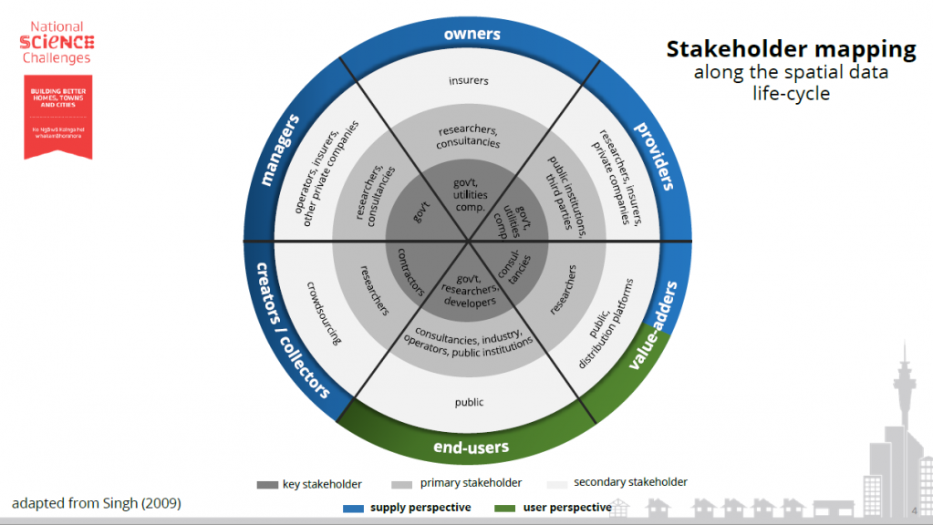
New Zealand’s urban planning community faces challenges regarding the availability and accessibility of fit-for-purpose (spatial) data. Gaining useful information about our built, social and natural environments, however, is increasingly essential for making good evidence-based decisions on urban development. Yet, there are visible differences across planning stakeholders and urban contexts in data availability, the use and understanding of essential data, and the ability to integrate them into urban decision-making.
This research project aims to improve the use of geospatial information for the development of better homes, towns and cities. It seeks a better understanding of the nature, availability and value of geospatial information for key urban planning stakeholders to making better evidence-based decisions about New Zealand’s cities. It assesses the landscape of (urban) spatial data in New Zealand through stakeholder engagement in the planning community and evaluation of purpose-specific data availability and quality, and needs and barriers to making key spatial information more openly accessible.
Main Research Outcomes
• Schindler M., Dionisio R. & Kingham S. (2018). A multi-level perspective of a spatial data ecosystem: needs and challenges among urban planning stakeholders in New Zealand. International Journal of Spatial Data Infrastructure Research, Vol 13. (Under Review)
• Schindler M., Dionisio R. & Kingham S. (2017). A multi-level perspective of New Zealand’s spatial data ecosystem: Needs, barriers and initiatives among the spatial planning community. New Zealand Geospatial Research Conference, 5-6 December, University of Canterbury, Christchurch.
• Schindler M., Dionisio R. & Kingham S. (2018). Challenges and potentials of the use of geospatial tools for evidence-based decision-making in New Zealand’s cities. Urbanism Conference, May 14-15, Wellington.
• Stevenson, J.R., & Schindler, M. (Producers). (2017 September). “Spatial Data for Researchers”. DOI: 10.6084/m9.figshare.5536483. Available from https://www.resorgs.org.nz/our-projects/resilience-natures-challenges-resilience-trajectories-future-proof-new-zealand/
• Stevenson, J.R., & Schindler, M. (Producers). (2017 September). “Spatial Metadata”. DOI: 110.6084/m9.figshare.5536489. Available from https://www.resorgs.org.nz/our-projects/resilience-natures-challenges-resilience-trajectories-future-proof-new-zealand/
• Stevenson, J.R., & Schindler, M. (2017 September). Getting the Most of Out of Your Research: Metadata, spatial data, and collaboration. Resilient Organisations. DOI: 10.6084/m9.figshare.5536513. Available from https://www.resorgs.org.nz/our-projects/resilience-natures-challenges-resilience-trajectories-future-proof-new-zealand/
• Stevenson, J.R., & Schindler, M. (Producers). (2017 June). “Metadata Overview”. DOI: 10.6084/m9.figshare.5421853. Available from https://www.resorgs.org.nz/our-projects/resilience-natures-challenges-resilience-trajectories-future-proof-new-zealand/
• Stevenson, J.R., & Schindler, M. (Producers). (2017 June). “Metadata: WhereDo I Start?”. DOI: 10.6084/m9.figshare.5536495. Available from https://www.resorgs.org.nz/our-projects/resilience-natures-challenges-resilience-trajectories-future-proof-new-zealand/