
 Speaker: Sara Mikaloff-Fletcher
Principal Scientist
Earth Sciences NZ
Sara Mikaloff-Fletcher is a Principal Scientist at Earth Sciences NZ and Chief Scientist of the Changing Atmosphere Flagship Programme. Her research focuses on using greenhouse gas observations from ground-based stations, aircraft, ships and satellites to quantify greenhouse gas emissions and carbon uptake. In particular, she is interested in quantifying greenhouse gas emissions and carbon uptake by the land biosphere at urban, regional and national scale to support climate mitigation and policy. She is the Science Leader for New Zealand’s MethaneSAT Science Project, a multi-institutional research programme focused on mapping agricultural emissions around the world from satellite data.
Seminar Summary:
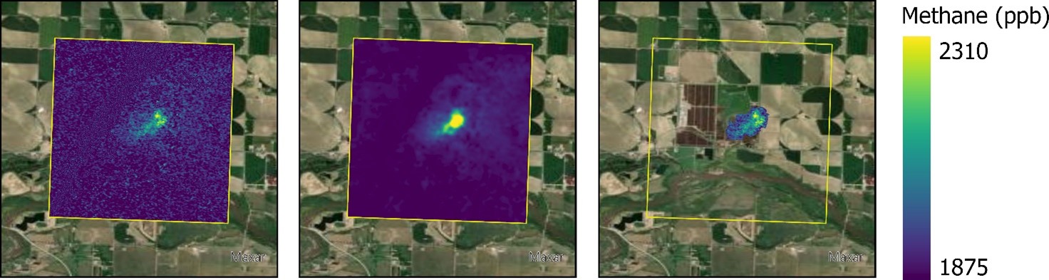
The MethaneSAT satellite is a joint American and Aotearoa-New Zealand initiative, involving a partnership between Environmental Defense Fund’s (EDF) subsidiary MethaneSAT LLC, and the New Zealand government. The satellite’s core mission is to support CH4 emission reductions around the world by measuring atmospheric CH4 with an unprecedented combination of precision, resolution, and imaging area. While MethaneSAT was designed to detect emissions from oil and gas infrastructure, it can also be used to measure agricultural methane emissions. New Zealand researchers lead the development and testing of the satellite’s agricultural emissions capability. In this talk, we will present results demonstrating MethaneSAT’s ability to quantify emissions from both intensive agriculture systems and in dispersed pastoral agriculture. We will show analysis of data from over 200 individual agricultural scenes over the United States from MethaneAIR, an airborne precursor instrument to MethaneSAT, which suggest methane emissions from intensive agricultural systems may be systematically under-estimated due to poor quantification of emissions from animal waste. Then, we will present preliminary results from MethaneSAT in New Zealand and compare these data to measurements from ground based remote sensing and aircraft collected as part of our field campaign. Sadly, MethaneSAT was lost after it’s first year, limiting the amount of data collected. We will discuss the next steps for our project using observations from other satellites and potential future directions for remote sensing of agricultural emissions from recently launched and planned satellites.
7th May 2026
Ernest Rutherford 263 | University of Canterbury or Online via Zoom
- Seminar: 1:00-2:00 pm
- Refreshments & Networking: 2:00-2:30 pm
Register for free at HUMANITIX: https://events.humanitix.com/methanesat
Join Zoom Meeting:
https://canterbury.zoom.us/j/95721632804?pwd=4JEFiibwzmoftp9E0KWS5Lj8iX9Nk6.1
Meeting ID: 957 2163 2804
Passcode: 145300

