
New Zealand’s Biological Heritage
A hapū-centric surveillance framework that focuses on the holistic health of the forest.
Authors
Co-leads: Waitangi Wood and Dean Anderson
Project teams: Audrey Lustig (MWLR), Ceclia Arienti (MWLR), Jo Peace (MWLR), Michael Martin (UoA), Sharmila Savarimuthu (GRI), Tracey Godfery (Kaitiaki Roopu)
Collaborators: Andrew Sanders (MPI), Beccy Ganley (Plant & Food), Carlton Bidois (Kaitiaki Roopu), Dave Milner (Kaitiaki Roopu), Ian Horner (Plant & Food), John Kean (AgResearch), Katrin Webb (DoC), Nari Williams (Plant & Food), Nick Waipara (Kaitiaki Roopu), Rodelyn Jacksons (Plant & Food)
Funding
New Zealand’s Biological Heritage National Science Challenge’s Ngā Rākau Taketake (‘NRT’)
Duration
2017-2020
Project summary
Plant pathogens are of a great concern in Aotearoa New Zealand and the wider south pacific because of the severe detrimental impacts they can have on environmentally, economically, and culturally significant flora and fauna. For example, kauri dieback is devastating the remnants of Aotearoa New Zealand’s iconic native kauri (Agathis australis) trees, and myrtle rust is threatening many iconic native species as well as plants important to primary industries. Surveillance has repeatedly emerged as a critical research priority in the management of these diseases. To date, data on the presence, host characteristics and severity of these diseases has been collected by many different New Zealand’s organizations, with data collection and management undertaken on a project-by-project basis. Few initiatives have integrated or supported indigenous knowledge, approaches and systems.
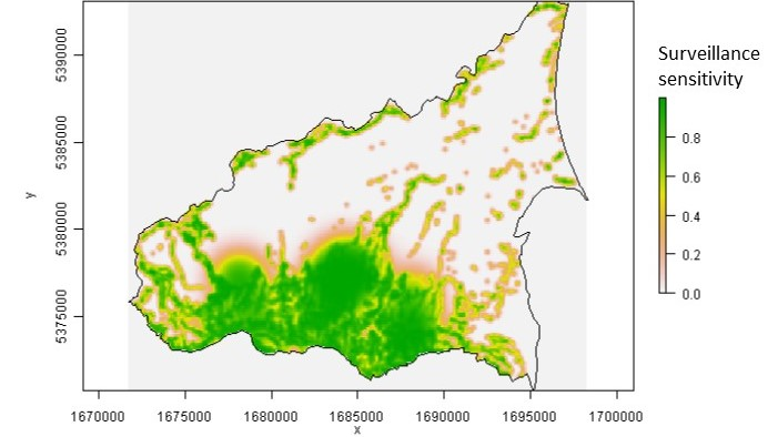
This project aims to develop a Mātauranga Māori Framework for Surveillance (MMFS) of plant pathogens that seeks to enable strategic trust relationships between hapū kaitiaki and rangatira (Maori authorities) directly with central, regional and local organizations that generate and provide science and research initiatives and investment, with particular focus on mātauranga Māori alongside western science. New Zealand’s surveillance system currently focuses on exotic pests and often overlooks ensuring healthy and resilient environments. The environment-centric surveillance framework focuses on ensuring the status of the environment is elevated into any surveillance response. It uses data and information important to indigenous ecosystems and narrative from rangatira, hapū and iwi, who have whakapapa (genealogical link) and kaitiaki (guardianship) of their taonga (treasured) species. The framework will use both existing and emergent understandings, values, approaches and opportunities to improve surveillance in Aotearoa New Zealand, recognizing the contribution from both western and Te Ao Māori experiences and intelligence.The MMFS will be tested using a surveillance-data analysis tool. This map-based tool will produce dynamic and updated information on the distribution of the diseases, severity, and the probability of absence (in areas where the disease has not been detected). The lack of a detection is not equivalent to absence. Therefore, the spatial variability in the probability of absence represents the risk of infection, which will vary with risk of spread from known infestations, and the amount of surveillance. The more we search for a pathogen and do not find it, the more confident we can be that it is not present. Results of the analysis will be available to users of the tool, which will help guide management and the development of novel research. Dr. Sharmila Savarimuthu from GRI joined the project as a software developer in October 2020. Her main role in this project is to develop the web-based surveillance-data analysis tool as well as to support the development of a national data infrastructure to collate surveillance data and information from a wide variety of stakeholders and Māori mana whenua to link the data back to the rohe (defined land area), as owners.
About Project
This research theme has been scoped in accordance with the New Zealand’s Biological Heritage National Science Challenge’s Ngā Rākau Taketake (‘NRT’) programme strategic objectives that aims to accelerate the critical research needed to combat the spread of kauri dieback (Phytophthora agathidicida) and myrtle rust (Austropuccinia psidii) in Aotearoa New Zealand.

